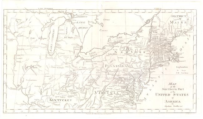
Subject: Eastern United States
Period: 1797 (published)
Publication: Morse's American Gazetteer
Color: Black & White
Size:
15.7 x 8.4 inches
39.9 x 21.3 cm
This map of the young United States presents early knowledge of topography and watersheds, roads and settlements. The map covers the region from the District of Maine south to Virginia and Kentuckey, and westward to just beyond the Mississippi River. West of the Mississippi lands are "Reserved by the U.S." In the western frontier are Large Meadows…, Coal Mines, and Very Large Meadows. St. Louis is located by a tiny dot. A Great Cave is located just west of Kentucky near the Ohio River. Lines show the "Indian Boundary" and "Gen. Wayne's Treaty 1795" line. Beyond this line numerous reservations are located including Chicago. The Western Reserve is here called New Connecticut. Five proposed new states are indicated with Roman numerals, which match closely Wisconsin, Michigan, Illinois, Indiana and Ohio. This is the first edition of Bradley's map.
References: Wheat & Brun #158.
Condition: B+
Issued folding. A slightly uneven impression with a minor abrasion below Long Island.