Subject: United States
Period: 1852 (dated)
Publication: Mitchell's School and Family Geography
Color: Hand Color
Size:
16.7 x 10.5 inches
42.4 x 26.7 cm
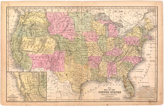
This double-page map contains transitional western borders including the important territorial acquisitions of the Mexican-American War, pre-Gadsden Purchase. The inset map "No. 6 Map of the Gold Region of California" delineates the Gold Regions, naming Sutter's Buttes, Sacramento City, and all of the important creeks of the gold region feeding into the Sacramento and Feather Rivers. The territories of Oregon and Washington extend to the Continental Divide. Minnesota Territory includes part of the Dakotas and the huge Missouri Territory rests between the Continental Divide and Minnesota, with Indian Territory bordering on to the south. Indian Territory is in its largest configuration, stretching from Texas to Missouri Territory along the North Fork of the Platte River and extending westward all the way to South Pass and Utah Territory. Utah is also at its largest, filling the region from California to Indian Territory along the Continental Divide.
References:
Condition: B
There is a centerfold separation and edge tear at bottom that each extend 0.25" into the map image that have been closed on verso. Light toning with a number of small brown stains in the image.