Subject: United States, Texas & Mexico
Period: 1844 (dated)
Publication: Olney's School Geography
Color: Hand Color
Size:
17.3 x 10.4 inches
43.9 x 26.4 cm
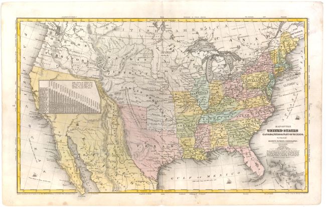
The United States and Great Britain established in 1818 joint claim over the Oregon Territory - the region north of Spanish controlled Upper California up to the southern boundary of Russia's Alaska Territory at North latitude 54°40'. By the late 1830's this arrangement was beginning to fall apart.
In the 1840's the expansionist Democrats, including their 1844 presidential candidate, James Polk, claimed the entire region for the United States. Their expansionist desires were expressed by Polk's famous campaign slogan, "Fifty-four Forty or Fight!" The slogan also became a rally cry for Americans desiring to settle the territory. Following Polk's election, the dispute was resolved by the 1846 Treaty of Oregon, which struck a compromise that fixed the U.S./Canadian boundary at 49º North.
This map shows the Independent Republic of Texas in its last full year as a republic. The panhandle extends well to the north. Austin is identified as the capital with many towns named including Houston, San Antonio de Bexar, and Columbus. To the west is a small region named Santa Fe or New Mexico. The huge Indian Territory to the north extends up to the Mandan District. The large area of the American Desert is shown mostly in Indian Territory, but extends into the panhandle of Texas. Mexico controls California and the Southwest, which is labeled Mexico, while the Baja is Old California. A large table of distances obscures much of northern California. The huge Oregon Territory reaches to the Continental Divide and well north into British America as part of the 54°50' or Fight controversy with England. East of Oregon is the large Mandan District that extends to an oversized Iowa at the Missouri River, that in turn extends to Wisconsin at the Mississippi River. The map has terrific territorial configurations and is filled with information on forts, Indian tribes, waterways and more. Copyright below neatline by D.F. Robinson. Drawn and engraved by Sherman & Smith, N.Y.
References:
Condition: B+
Some light soiling.