Subject: Canada
Period: 1801 (dated)
Publication: Voyages from Montreal, on the River St. Laurence…
Color: Hand Color
Size:
11 x 7 inches
27.9 x 17.8 cm
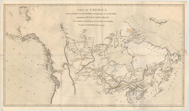
Alexander Mackenzie was the first white man to cross the North American continent north of Mexico and thus dispel the belief in a Northwest Passage to Hudson Bay. His epic journey was one of incredible hardship and marks an important page in the cartographic history of North America. This map shows the entire track of both the 1789 and 1793 expeditions from Montreal to the Arctic Sea and Pacific Ocean.
The first expedition set out in 1789 to test Peter Pond's theory that Cook Inlet was the mouth of a large westward-flowing river that would provide a route to the Pacific. After a most difficult 2500 km canoe trip, the expedition found itself at the Arctic Ocean, not the Pacific. The second expedition set out in May 1793, with men and Indians from the Beaver tribe. After a long journey traveling via rivers and overland, Mackenzie finally arrived at the Pacific Ocean. The map details both expeditions via line and hand coloring. The map is finely engraved with good overall detail showing major waterways, lakes, and a few mountain ranges. An uncommon map.
References:
Condition: B
There is an edge tear at right that extends 9.5" into the image, and a small hole and separation along one fold at right that have all been closed on verso. There are several worm tracks along the upper and lower neatline with some minor offsetting. Issued folding.