Subject: France
Period: 1730 (circa)
Publication:
Color: Hand Color
Size:
38.3 x 23.8 inches
97.3 x 60.5 cm
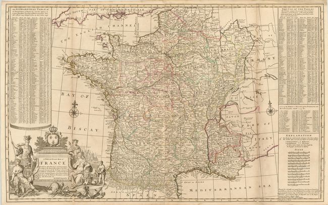
This decorative two-sheet map of France is filled with details of towns, rivers, roads, and the topography of the land. The postal roads are marked with distances between points indicated in leagues. Battle sites in which the English were involved are marked with a sword and a date. The map is flanked by an alphabetical index of several hundred towns in France along with their distance from Paris. Moll also included a unique feature - a list of Ports or Passes of the Pyrenean Mountains. The large allegorical title cartouche features Bacchus, the god of wine, and Athena, the goddess of war and wisdom, beside a large royal coat of arms. In the foreground are weaponry, cartographic tools, and symbols of the art and culture of the country, while the rival observatories of Paris and Greenwich can be seen in the distance. This map was first issued separately and then published in several of Moll's atlases: The World Described, New and Compleat Atlas, and Athlas Royal. This edition was sold by several map sellers as indicated in the imprint at bottom right, including Thomas Bowles, his son John Bowles, Philip Overton, and John King.
References: Shirley (BL Atlases) #T.Moll-4b [23].
Condition: B+
Original outline color with light toning along folds and a few small spots. Long fold separations at bottom have been professionally repaired.