Subject: World
Period: 1717 (dated)
Publication: L'Atlas Curieux ou le Monde...
Color: Hand Color
Size:
13.2 x 9 inches
33.5 x 22.9 cm
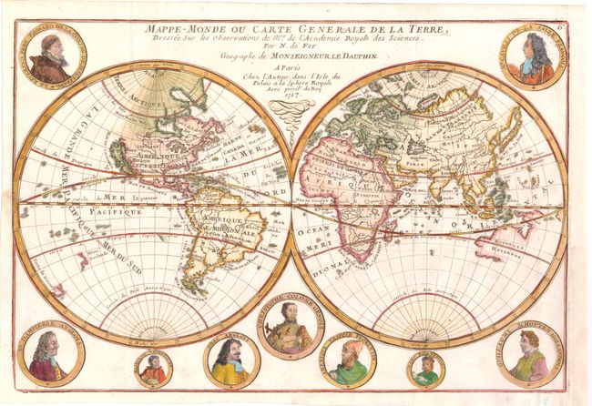
Fine double hemispheric map that features California as an island. Surrounding the hemispheres are nine medallion portraits of explorers, including La Salle, Tachard, Dampier, Magellan, Drake, Columbus, Vespucci, Marco Polo, and Schouten. The map shows early mapping of North America with the Great Lakes not completely formed. The northeast coast of Asia includes a coastline labeled Roye. de Coree stretching off the map in the direction of North America. Australia and New Zealand are tentatively drawn and named Nouvelle Hollande and Nouv. Zeeland. According to Shirley, this map may have been copied directly from the similar map by Mortier (see Shirley 572), however since the dating on the Mortier map is uncertain, it is possible that Mortier copied de Fer. This is the third edition, dated 1717.
References: Shirley #601; Pastoureau, FER 1D.
Condition: A
Nice coloring on watermarked paper. Issued folding with a binding trim and resulting 1" binding tear that have both been professionally repaired.