Catalog Archive
Auction 142, Lot 198

"Map of an Exploring Expedition to the Rocky Mountains in the Year 1842 and to Oregon & North California in the Years 1843-44", Fremont, John Charles

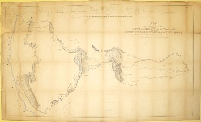
Subject: Western United States

Period: 1845 (published)

Publication:

Color: Hand Color

Size:
51.6 x 30.4 inches
131.1 x 77.2 cm
Download High Resolution Image
(or just click on image to launch the Zoom viewer)

John C. Fremont is an important historical figure best remembered for his three explorations of the west in the 1840s. Fremont married Jessie Benton, daughter of Sen. Thomas Hart Benton in 1841. The Senator championed the idea of Manifest Destiny, pushing for national surveys of the West and arranging for his son-in-law to lead them.

From 1842 to 1846 Fremont led three explorations of the west with Kit Carson as guide and Charles Preuss as the topographer. His early route became know as the Oregon Trail and his explorations are credited with encouraging the huge overland migration to the west. He was the first American to see Lake Tahoe, and finally determined that the Great Basin is endorheic, or closed basin with no outlet to the sea.

Fremont went on to become a millionaire, a California senator, a governor to Arizona Territory, the man who is credited with saving Kit Carson's life, and much more, yet died penniless and in virtual obscurity. Some scholars regard Fremont as a hero of significant accomplishment, while others view him as a failure who repeatedly defeated his own best ideals. He remains an enigmatic figure in the history of the United States. Read more of his fascinating story here.

This is the large edition of the influential map which details John Charles Fremont's epic exploration of the American West. Fremont and his traveling companion and topographer, George Carl Preuss, launched the expedition from the frontier settlement of Westport at the juncture of the Kansas and Missouri Rivers. There Fremont first met Kit Carson who signed on as guide to the expedition. Traveling across the Rocky Mountains at South Pass to the Columbia River in Oregon Territory, they then continued south along the Sierra Nevada nearly to the "Pueblo del los Angeles", northeast to Lake Utah and finally east to the Arkansas River. Fremont's map and report had a profound influence on emigration to the Far West as his westward route eventually became the Oregon Trail. Wheat, who called this "an important step forward from the earlier western maps" devoted seven text pages to its description. The map was drawn by Charles Preuss "whose skill in sketching topography has probably never been surpassed in this country." There is much to study and appreciate in this rare map, but we return to Wheat for this short praise: "To Fremont and his magnificent map of his Second Expedition all praise. This is an altogether memorable document in the cartographic history of the West, and for it alone Fremont would deserve to be remembered in history."

References: Wheat (TMW) #497; Howes F370; Wagner-Camp #115.

Condition: C+

Issued folding and now pressed flat with a 1" x 2" area of loss at top left and a few other smaller areas of loss along one fold that have been repaired with archival material on verso. Backed with tissue to reinforce and repair a few fold separations. There is some scattered foxing, light toning, and slight show-through of the previous owner's stamp on verso at bottom.

Estimate: $700 - $900

Sold for: $500

Closed on 11/28/2012

Archived