Subject: Colonial New England and Mid-Atlantic
Period: 1671 (circa)
Publication: De Nieuwe en Onbekende Weereld
Color: Hand Color
Size:
14.5 x 11.5 inches
36.8 x 29.2 cm
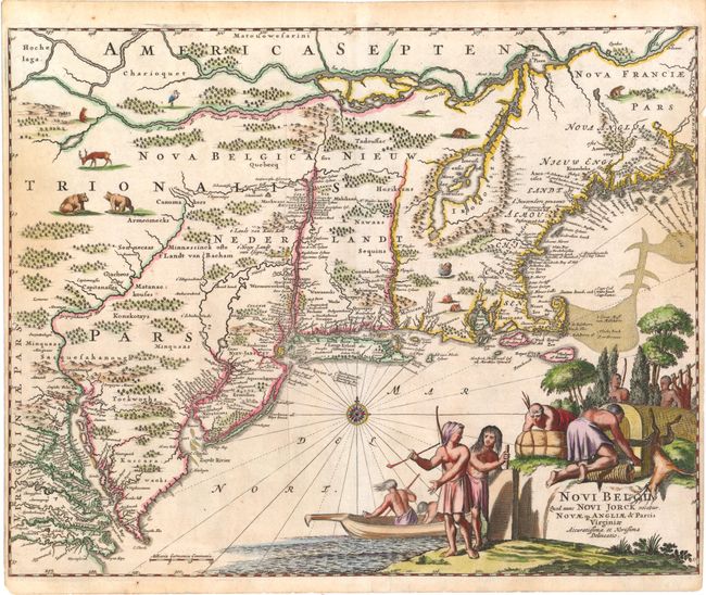
Montanus' work was perhaps the greatest illustrated book on the New World produced in the seventeenth century. It contained over one hundred beautifully engraved plates, views, and maps of North and South America. The plates vividly depict forts, festivals, occupations, Dutch fleets, battles, religious rites, and customs of the native inhabitants. This important work was translated into German by Olivier Dapper, and into English by John Ogilby. Several of the plates were later acquired by Pierre Vander Aa.
This finely engraved map is based on the influential Jansson-Visscher series. Geographically the map follows Jansson, including the placement of nearly every European settlement along the coastline and rivers. It covers the Eastern seaboard from just below the Chesapeake Bay to Pennobscot Bay. Most of the interior details appear sketchy and speculative and are occupied by large forests and wild animals. Many of the place names have been revised to reflect the loss of the Dutch colony to the British in 1664. While Nieuw Nederlandt still appears for the region, the city is named Nieu Jorck, the Dutch Fort Organie is named Albany, and Nieu Jarsey is now named. The unique decorative elements shows Native Americans in a variety of occupations.
References: Campbell (MCC-24) #21; McCorkle #671.1.
Condition: B+
A fine impression on watermarked paper with attractive color and light stains at right and left. Trimmed close to neatlines at right and left, as issued.