Subject: Pakistan, Afghanistan & India
Period: 1490 (circa)
Publication: Geographia
Color: Hand Color
Size:
18 x 15.3 inches
45.7 x 38.9 cm
Claudius Ptolemy was a mathematician, astronomer and geographer who worked in Alexandria, then a part of the Roman Empire, in the 2nd century AD. One of the most learned and influential men of his time, his theories dominated both astronomy and geography for nearly 1500 years. His writings were kept alive by Arabic scholars during the Middle Ages and reemerged in Europe during the Renaissance. The birth of printing led to wide dissemination of his great works on astronomy and geography. There were a number of editions of his Geographia beginning in 1477. These early editions contained maps based on his original writings, known as Ptolemaic maps. As geographic knowledge increased with the explorations of Columbus, Magellan, Cabot and others, maps of the New World were added, and maps of the Old World were revised. Ptolemy's Geographia continued to be revised and published by some of the most important cartographers including Martin Waldseemuller, Sebastian Munster, Giacomo Gastaldi, Jodocus Hondius, and Gerard Mercator (whose last edition was published in 1730).
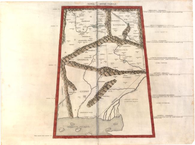
This striking copper-engraved map provides a Ptolemaic view of the region of present-day Pakistan, Afghanistan and northern India. The historic regions of Gedrosia, Drangia, Aria, Paropanisus, and Arachosia are prominently located with their rope-like mountainous boundaries. This map was only used in 4 editions of Ptolemy's Geographia (1478, 1490, 1507 and 1508) all published in Rome. German printers Conrad Sweynheym of Main and Arnold Buckinck supervised the engraving for the Rome editions. Sweynheym, who apprenticed with Johann Guttenberg, introduced the printing press to Italy and developed the method of the "punched letter" printing. His work is extremely important in the evolution of the printed map.
References: Nordenskiöld, A.E. (Facsimile) fig. XXIV; Mickwitz & Miekkavaara #196-24.
Condition: B
Watermarked paper with wear and staining along joint, with tiny areas of surface loss. There are a few small stains in blank margins.