Catalog Archive
Auction 141, Lot 432

"A Mapp of the Kingdome of Dennmarke, with its Severall Dioeceses or Provinces…", Blome, Richard
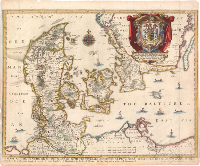
Subject: Denmark

Period: 1667 (dated)

Publication: Geographical Description Of The Four Parts Of The World

Color: Hand Color

Size:
15.5 x 12 inches
39.4 x 30.5 cm
Download High Resolution Image
(or just click on image to launch the Zoom viewer)

This scarce map is from the first atlas to be wholly engraved, printed and published in England. This map covers all of Denmark and also parts of northern Poland and Germany to include all of Holstein, the islands of Sjaelland, Fyn and Lolland, and the southern part of Sweden. The map is embellished with an elaborate heraldic cartouche and a dedication to "George, Lord Berkeley...descended from Harding a younger son of one of ye Danish Kings…" Further decorated with a fine 32-point compass rose, plus seas filled with ships and sea monsters. The 24 maps in the atlas were engraved by Francis Lamb, Thomas Burnford and Wenceslas Hollar. Although the map is dated 1667, Blome's Geographical Description was first published in 1670. This map is after Nicolas Sanson and was engraved by Hollar.

Richard Blome was one of the most interesting, and most active, publishers of illustrated books in post-Restoration London. There is an excellent biography on MapForum.com.

References: Shirley (BL Atlases) T.Blom-1a #20.

Condition: B+

Watermarked paper with a couple of faint spots and narrow, but adequate, side margins. The centerfold and sheet edges have been reinforced on verso with tissue, repairing some tiny tears and fold separations confined to blank margins.

Estimate: $190 - $230

Sold for: $450

Closed on 9/5/2012

Archived