Subject: Oklahoma, Southern United States
Period: 1884-95 (circa)
Publication:
Color:
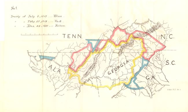
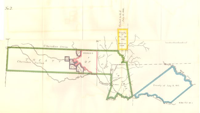
A. [Lot of 2 - Cherokee Nation] No. 1 [and] No. 2, by U.S. Government, HR Doc No. 182, 53rd Cong., 3rd Sess., circa 1895, black & white. Two numbered, but untitled maps originally issued with the report, "Moneys Due the Cherokee Nation." No. 1 consists of portions of North Carolina, Georgia, Alabama, and Tennessee. Colored boundaries and key indicate the land involved in the treaties of 1817, 1819, and 1835 (20" x 12"). No. 2 shows the Cherokee Strip and the Cherokee Outlet in the Indian Territory. Colored boundaries indicate various treaties and possessions of other tribes (25" x 13"). Both folding, as issued. The report is not included. Condition: Light offsetting. (A)
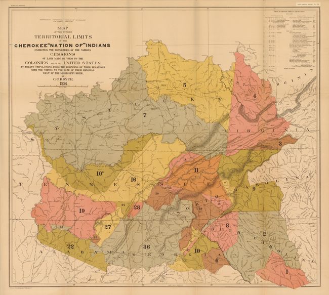
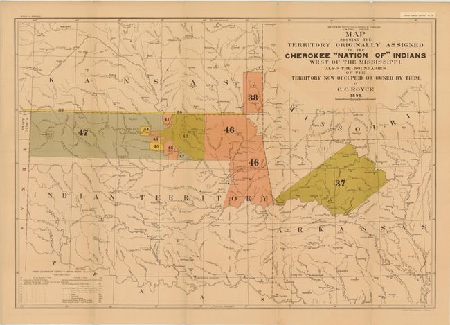
B. [Lot of 2] Map Showing the Territory Originally Assigned to the Cherokee "Nation of" Indians West of the Mississippi... [and] Map of the Former Territorial Limits of the Cherokee "Nation of" Indians Exhibiting the Boundaries of the Various Cessions of Land Made by Them to the Colonies and to the United States by Treaty Stipulations..., by C.C. Royce, 5th Annual Report Bureau of Ethnology, dated 1884, printed color. A matched pair of important Cherokee Nation maps. The first title continues, "...Made by Them to the Colonies and to the United States by Treaty Stipulations, from the Beginning of Their Relations with the Whites to the Date of Their Removal West of the Mississippi River." It shows the former territorial limits of the Cherokee Nation between the Ohio and Tennessee rivers and the Appalachian Mountains. A key lists 36 cessions from 1721 to 1835 which are numbered and colored on the map (31 x 28"). The second map's title continues "Also the Boundaries of the Territories Now Occupied Or Owned by Them" and lists cessions 37-47, Treaties of May 6, 1828 and July 19, 1866. This map also includes a small section of Public Lands, Kansas and Arkansas. Shows many villages, forts and Indian Agencies (30 x 20.5"). A terrific pair of large maps portraying an important period in U.S. and Native American history and relations. Condition: There are a number of short splits at fold intersections, light toning, and minor offsetting. (B)
References:
Condition:
See description above.