Subject: China, Korea & Japan
Period: 1626 (dated)
Publication: A Prospect of the Most Famous Parts of the World
Color: Hand Color
Size:
20.3 x 15.5 inches
51.6 x 39.4 cm
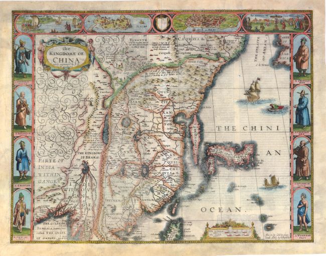
This superb map of China, Korea and Japan is the only carte-a-figures map made of the region. The Great Wall protects the Kingdom of China from a variety of evil creatures that occupy The Desert Lop, and the rest of the kingdom is delineated by a long range of mountains in the west that separates it from The Kingdome of Bramas. Korea is a long island and Japan is presented on the Ortelius-Teixeira model. The decorative panel at top features bird's-eye plans of Macao (copied from DeBry) and Qyinzay (Hangzhou) along with scenes depicting ingeniously crafted wind-carts and their manner of execution (crucifixion). The inhabitants of the region are shown at sides, including a very early depiction of a Japanese soldier. There are interesting notes throughout the map on various historical and mythical aspects of the region, including where men are seduced by wonderful illusions and where fireproof cloth is woven. The English text on verso provides an equally fascinating description of Chinese culture. George Humble's imprint at Popshead Alley is at lower right.
References: Cortazzi, plt. 29; Manasek #56; Shirley (BL Atlases) T.SPE-2a #19.
Condition: B
A slightly uneven impression with show-through of text on verso and a few tiny holes caused by imperfections in the paper. There is an expertly repaired long tear adjacent to <i>Lake of Chiamay</i> and a couple of small holes with loss of image. There are other professional repairs to tears and chips in blank margins, one of which enters 1/2" into image at bottom left with a small amount of border in facsimile.