Subject: Cartographic Miscellany
Period: 1850 (circa)
Publication: Illustrated Atlas and Modern History of the World
Color: Hand Color
Size:
10 x 14 inches
25.4 x 35.6 cm
The maps from The Illustrated Atlas were first published in serial form to a target audience that led insular lives due to the expense and hardship of travel. All that changed as the progress of the nineteenth century brought swift and dramatic changes in public awareness of far away places. Tallis' maps no doubt played an important role in this dramatic awakening. These maps not only provided up-to-date geographical knowledge, but also used vignette views within the map's design to show the native people and their occupations, cities and points of interest. The maps hark back to a cartographic tradition from the Dutch mapmakers of the seventeenth century with finely engraved decorative borders. The maps were drawn and engraved by John Rapkin with views drawn and engraved by a number of prominent artists. The maps were issued as a complete volume from 1851 until about 1865. Some of the maps were also published in other history books published by Tallis including British Colonies and, without the vignettes, in geographical dictionaries and encyclopedias until about 1880.
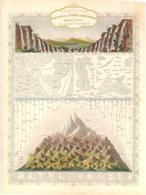
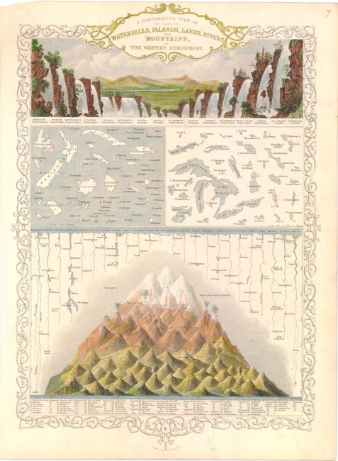
This lot is a handsome, matched pair of thematic maps. They show the lakes, waterfalls, islands, rivers and mountains in separate panels. The central panels show land masses and water masses on the same scale, making a visual comparison of the hemispheres quite simple. The mountain panels have a key below identifying each mountain and volcano: 84 in the Eastern and 68 in the Western Hemisphere. Finely engraved with fancy borders and titling.
References:
Condition: A
Near fine examples with just a little light edge toning away from map.