Subject: Central Europe
Period: 1761 (dated)
Publication:
Color: Hand Color
Size:
53.5 x 24.5 inches
135.9 x 62.2 cm
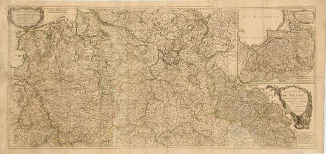
This impressive, large-scale map depicts parts of central Europe during the Third Silesian War (part of the Seven Years' War). Two rococo-style title cartouches attribute the cartography to Homann. The map extends from Luxembourg and the Netherlands in the west to western Poland in the east and depicts towns, roads, boundary lines, and the topography of the land. A large inset of northeastern Poland is at top right, with its own title cartouche, Carte Particuliere de la Prusse Royale…. Printed on 3 sheets, joined as issued.
References:
Condition: C+
Original outline color on watermarked paper with light soiling, tiny worm holes, and a couple of short cracks. There are numerous separations along the horizontal fold, the majority of which have been closed on verso with archival materials. There is a tear that enters 3" into map at left and another 3" tear to the left of the main title cartouche that have both been archivally repaired.