Subject: Illinois
Period: 1864 (dated)
Publication:
Color: Black & White
Size:
22 x 15 inches
55.9 x 38.1 cm
The Office of Coast Survey is the oldest U.S. scientific organization, dating from 1807 when Congress directed that a "survey of the coast" be carried out. By 1836, it was called the U.S. Coast Survey and in 1878, the name was changed to the U.S. Coast and Geodetic Survey. Today the Office of Coast Survey is a division of the National Oceanic and Atmospheric Administration NOAA.
The survey teams, composed of civilians as well as Army and Naval officers, charted the nation's waterways and produced a wide array of reports, survey charts, hydrographic studies of tides and currents, astronomical studies and observations, and coastal pilots. These charts are an important record of the changing nature of the nation's coastlines. In additional to coastal charts, the U.S. Coast and Geodetic Survey produced land sketches, Civil War battle maps, and the early aeronautical charts.
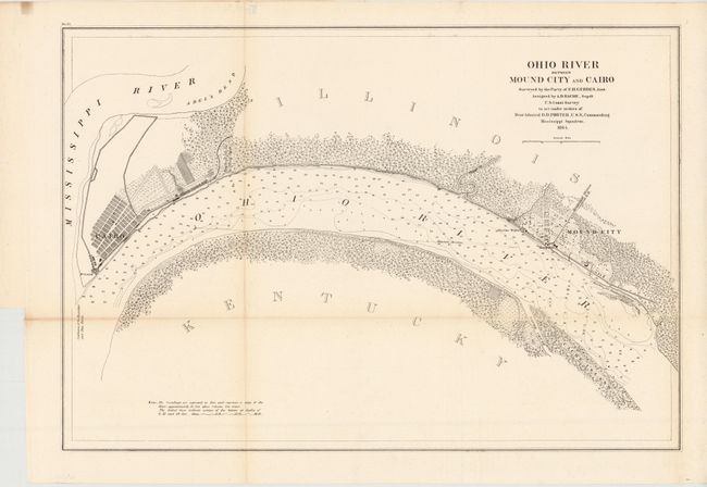
This map was surveyed and prepared during the Civil War under order of Rear Admiral Porter, Commander of the Mississippi Squadron, so military and industrial facilities are emphasized. Fort Cairo, a naval depot, hospital and the Illinois Central Rail Road are shown.
References: Stephenson #213.5
Condition: B+
There is some light toning along two of the folds and a binding trim at lower left.