Subject: Mid-Atlantic United States
Period: 1832 (dated)
Publication:
Color: Black & White
Size:
41 x 12.3 inches
104.1 x 31.2 cm
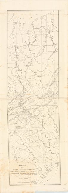
This map details the country between Lake Erie south to the Atlantic Ocean near Savannah. The route of the proposed road originates in Portsmouth on the Ohio River and meanders down through Kentucky, [now] West Virginia, Tennessee and to the Vicinity of Morgantown in North Carolina. The National Road is shown running between Columbus and east to Brownsville, PA. The map locates Louisville, Sparta, Savannah, Charleston, Columbia, Parkersburg, Pittsburgh, Cleveland and many more. Important places like the Charleston Salt Works are also located. Drawn by Lieut. F.L. Darcy under the direction of Lieut. Col. S.H. Long, Topographical Engineers. Signed in the plate.
References:
Condition: B
There is some light staining primarily near the title and along the edges in the blank margins. Issued folding.