Subject: Western Hemisphere
Period: 1587 (dated)
Publication: Theatrum Orbis Terrarum
Color: Hand Color
Size:
19 x 14 inches
48.3 x 35.6 cm
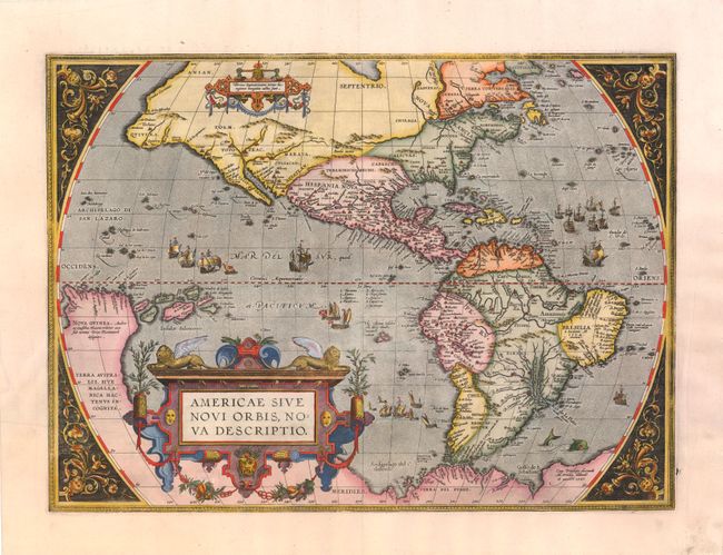
This is one of the most famous maps of America and one that had enormous influence on the future cartography of the New World. Frans Hogenberg engraved this map and it is primarily based on Gerard Mercator's great multi-sheet world map of 1569. The map features an exaggerated breadth of the North American continent, with a lengthy St. Lawrence River reaching across the continent to nearly meet the fictitious, westward flowing Tiguas Rio. The strategically placed title cartouche hides the unknown South Pacific and therefore most of the conjectural great southern continent, which is shown attached to both New Guinea and Tierra del Fuego. This is the third of the plates that Ortelius used of the Americas, evidenced by the removal of the bulge on the southwestern coast of South America and an added cartouche in North America. Also on this plate, the Solomon Islands are noted for the first time since their discovery in 1568, and the names California, R. de los estrechos, and C. Mendocino have been added to the west coast of North America. The native name of Wingandekoa has been added to the eastern coast, originating from an unsuccessful attempt to colonize the Outer Banks by the English. French text on verso, published in 1598.
References: Burden #64; Van den Broecke #11.
Condition: A
A fine impression with wide, original margins and light soiling in bottom right blank margin.