Subject: Colonial Southeast
Period: 1630 (circa)
Publication: Atlas Minor
Color: Black & White
Size:
10 x 7.5 inches
25.4 x 19.1 cm
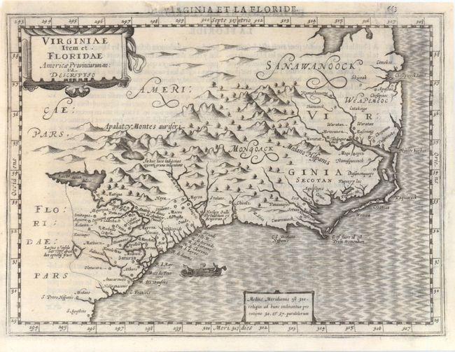
This uncommon map is one of four relating to North America that appeared in the reduced size Mercator/Hondius atlas by Cloppenburgh. Derived from the influential Jodocus Hondius map of the same name, Cloppenburgh closely followed the cartography but eliminated some of the decorative elements due to the smaller size. Hondius' map was compiled from two of the most important source maps of the early colonial period: John White's Virginia and Jacques le Moyne's Florida. Le Moyne's erroneous depiction of a large inland lake (Lacus aquae dulcis) from which the R. de May (St. John's River) flows in a southeasterly direction is shown at left. Chesapeake Bay, here called Chesepioock Sinus, and the area south towards C.S. Romano Hispanis are shown in their White delineations. The Indian villages of Paquiwok, Croatoan, and Wococon are named in the Outer Banks and several others along the Albemarle and Pamlico Sounds. An illustration of Virginian natives in a canoe (taken from De Bry) graces the Atlantic. This is the first state, with French text on verso.
References: Burden #227.
Condition: B
There is minor show through of the text on verso. A tiny worm hole at bottom left, a tiny hole at top right, a 1" tear in lower cartouche, and a tear that just enters map border at top right have all been archivally repaired and backed with Japanese tissue.