Catalog Archive
Auction 139, Lot 134
"[Lot of 3] Der Nordliche Theil der Vereinigten Staaten von Nord America… [and] Etats-Unis… [and] Verein-Staaten von Nord-America, Mexico, Yucatan U. A."
Subject: United States
Period: 1832-51 (circa)
Publication:
Color: Hand Color
Size:
See Description
Download High Resolution Image
(or just click on image to launch the Zoom viewer)
(or just click on image to launch the Zoom viewer)
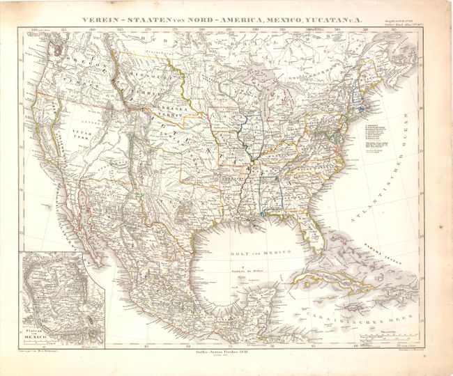
A. Verein-Staaten von Nord-America, Mexico, Yucatan U. A. by Adolph Stieler, dated 1851, (15.5" x 12.8"). This handsome German map shows the important territorial acquisitions of the Mexican-American War, pre-Gadsden Purchase, plus the new state of California - though the borders are incorrectly shown so that San Diego is in Yutah Terr., which encompasses the balance of the former Upper California region. Several Indian tribes are located in this region that is otherwise noted as . The Oregon Territory extends to the Continental Divide. Minnesota Territory includes part of the Dakotas and the huge Missouri Territory rests between the Continental Divide and Minnesota, with Indian Territory bordering on to the south. Indian Territory is in its largest configuration, stretching from Texas to Missouri Territory along the North Fork of the Platte River and extending westward all the way to South Pass. Texas is shown in an early configuration with a tall panhandle and New Mexico is a narrow territory along the upper Rio Grande River. An inset details the Plateau von Mexico including the salt marsh of the Texcoco Lake (Texcuco See). Condition - original outline color with minor soiling in the blank margins, else fine. (A)
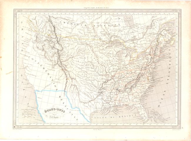
B. Etats-Unis by A. H. Dufour, circa 1840, (14" x 10"). This French map of the United States shows the boundary between the U.S. and Mexico that was established in 1848 outlined only in color over the engraved map that shows the Southwest as part of the Confederation Mexicaine. The emerging railroad network is delineated in red with good detail of the Indian tribes and districts along with forts in both Canada and the United States. Condition - original outline color with a tiny hole in the lower left neatline and a few small stains in the image. (B+)
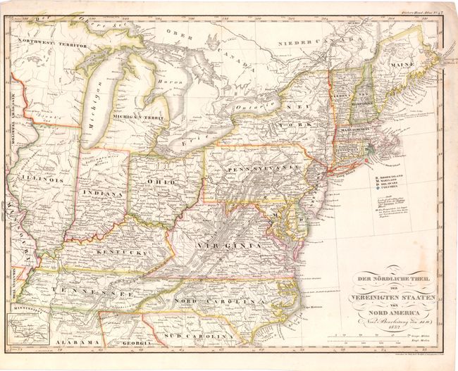
C. Der Nordliche Theil der Vereinigten Staaten von Nord America… by Adolph Stieler, dated 1832, (15.5" x 12"). This German map covers the Midwest and the Eastern Seaboard. It provides good detail in the newly settled Midwest; Indiana, Illinois, Missouri, Michigan and Northwest Territories with several early forts and Indian tribes shown. A small inset follows the Missouri River west through Jefferson, Franklin, Chariton. Condition - original outline color with a few small stains in the image. (B+)
B. Etats-Unis by A. H. Dufour, circa 1840, (14" x 10"). This French map of the United States shows the boundary between the U.S. and Mexico that was established in 1848 outlined only in color over the engraved map that shows the Southwest as part of the Confederation Mexicaine. The emerging railroad network is delineated in red with good detail of the Indian tribes and districts along with forts in both Canada and the United States. Condition - original outline color with a tiny hole in the lower left neatline and a few small stains in the image. (B+)
C. Der Nordliche Theil der Vereinigten Staaten von Nord America… by Adolph Stieler, dated 1832, (15.5" x 12"). This German map covers the Midwest and the Eastern Seaboard. It provides good detail in the newly settled Midwest; Indiana, Illinois, Missouri, Michigan and Northwest Territories with several early forts and Indian tribes shown. A small inset follows the Missouri River west through Jefferson, Franklin, Chariton. Condition - original outline color with a few small stains in the image. (B+)