Subject: Africa
Period: 1650 (circa)
Publication:
Color: Black & White
Size:
18.3 x 14.3 inches
46.5 x 36.3 cm
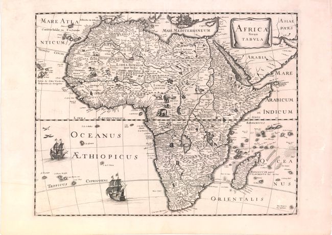
Although lacking an imprint for either the cartographer or engraver, this stunning map of Africa is attributed to Pierre Mariette due to its similarity to Mariette's map of the Americas, America Nouiter Delineata, which was included in Mariette's Theatre Geographique de France. However, the engraving style and decorative elements on the map suggest that it may have been made by a Dutch engraver, possibly Cornelis Dankerts, who worked with Mariette on occasion.
Based on Jodocus Hondius' 1619 map of Africa, this map retains the same geography and decorative elements throughout the continent, although the animals are depicted in reverse. The geography is largely speculative and follows Blaeu's map of 1617 with the Cuama River originating in the mountains rather than in the Sachaf Lake below the Mountains of the Moon (Lunae Montes). The origin of the Nile conforms to the Ptolemaic tradition of the two twin lakes south of the equator. The Kingdom of Monomotapa occupies a large area of southern Africa. A simple, square drapery cartouche, two French sailing ships, and two flying fish adorn the map.
References: Betz #80; cf. Burden #300.
Condition: A
A dark impression and wide margins on watermarked paper with faint offsetting and a few insignificant spots in blank margins.