Subject: California and Baja Mexico
Period: 1772 (published)
Publication: Diderot's Encyclopedie (Supplement)
Color: Black & White
Size:
14.5 x 11.5 inches
36.8 x 29.2 cm
When Charles Joseph Panckoucke took over publication of Diderot's Encyclopedie in 1768, he promised to correct the cursory treatment of geography for which the first seventeen volumes had been criticized, with emphasis on the discoveries of the last 25 years. He employed Samuel Engel, a Swiss geographer, to write a series of articles about the northern regions and Didier Robert de Vaugondy to prepare ten maps to illustrate them. Engel rejected the De la Fonte Northwest Passage discoveries and believed the most sensible route from the Atlantic to the Pacific was along the north coast of Siberia. These maps illustrate the discoveries and various cartographic theories concerning the Pacific Northwest, East Asia and the North Pacific Ocean and include some of the most interesting comparative cartography of the eighteenth century
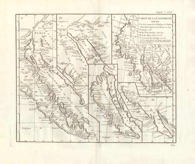
This sheet has five depictions of California that present a fascinating cartographic history of the region. The first map reproduces Neron Pecci's map of 1604 showing the peninsula with a ragged coastline and place names derived from Cabrillo's voyage of 1542-3. The second map is a detail from Sanson's 1656 map showing the island of California with place names from the voyage of Vizcaino. Map three is from Delisle's map of America of 1700 with the question of California's insularity left open to interpretation. Map four is Kino's important map of 1705 that finally ended that cartographic myth. Finally, map five is a portion of a Spanish map, showing the Jesuit explorations, that first appeared in Miguel Venegas' Noticia de la California in 1767, which is the first published history of California. This is an important map for any California map collection. Above upper right neatline "Supp. 5e Carte" and below right is page number 164.
References: McLaughlin #241; Fite & Freeman #52; Heckrotte & Sweetkind #15; Pedley #474.
Condition: A
Nice dark impression with only a hint of offsetting, else fine.