Subject: California
Period: 1852 (dated)
Publication:
Color: Black & White
Size:
22.5 x 22 inches
57.2 x 55.9 cm
The Office of Coast Survey is the oldest U.S. scientific organization, dating from 1807 when Congress directed that a "survey of the coast" be carried out. By 1836, it was called the U.S. Coast Survey and in 1878, the name was changed to the U.S. Coast and Geodetic Survey. Today the Office of Coast Survey is a division of the National Oceanic and Atmospheric Administration NOAA.
The survey teams, composed of civilians as well as Army and Naval officers, charted the nation's waterways and produced a wide array of reports, survey charts, hydrographic studies of tides and currents, astronomical studies and observations, and coastal pilots. These charts are an important record of the changing nature of the nation's coastlines. In additional to coastal charts, the U.S. Coast and Geodetic Survey produced land sketches, Civil War battle maps, and the early aeronautical charts.
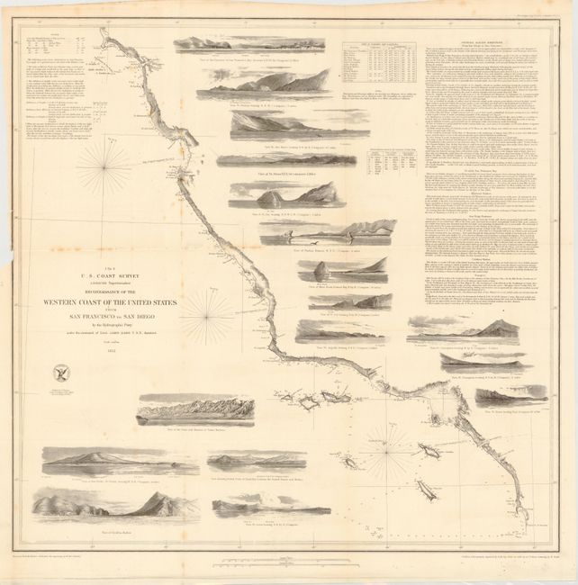
This terrific chart delineates the coast and is from the first official scientific reconnaissance of the Pacific coastal areas. It is one of three prepared by Lieutenant James Alden for this important survey. This sheet covers the region from the Mexican boundary to Point Reyes. It outlines the coastal littoral, shows dangerous reefs and shoals, gives offshore bathymetric soundings, plus general and specific harbor sailing instructions. The most impressive feature is the 17 views of entrances and promontories along this rugged coastline - among them Santa Barbara, Catalina Harbor, and the entrance to San Francisco Bay. The map was drawn by W.M. McMurtie and engraved by G. McCoy. Engraving of the views is also by McCoy and S.V. Hunt. This is one of the finest Coast Survey charts produced, and should not be confused with the simpler, and slightly smaller, charts that do not feature the large number of coastal views.
References: Schwartz & Ehrenberg, plt. #174; Heckrotte & Sweetkind #33.
Condition: B
There is a small loss of neatline and a tear that extends one-inch beyond the neatline at left binding trim with some minor staining along a few folds. Issued folding.