Subject: Central United States
Period: 1867-71 (circa)
Publication:
Color: Hand Color
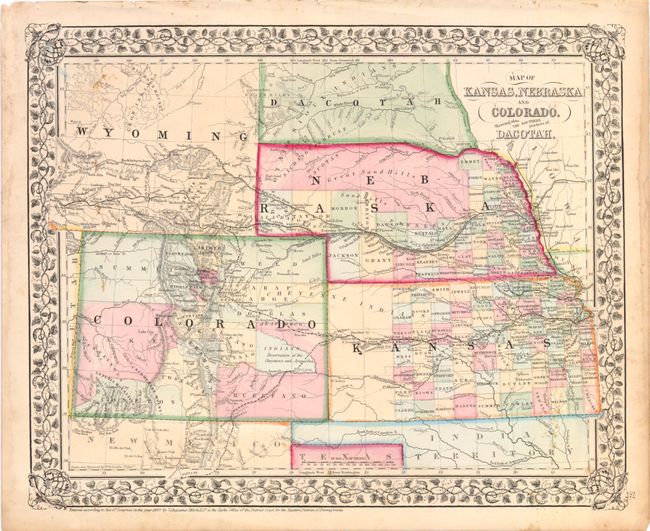
A. Map of Kansas, Nebraska and Colorado. Showing also the Southern Portions of Dacotah, Mitchell, dated 1867, hand color (14.3 x 11.3"). This map details Kansas, Nebraska and Colorado and the southern portion of Dakota. It also shows a large portion of the new Wyoming Territory that was organized in 1868 from the southwestern part of Dakota Territory. Counties, cities, towns, transportation routes, Reservations, and topographical features are illustrated. County development in Kansas stops at Ft. Atkinson, and in Nebraska the northern portion is unorganized. In Colorado the Gold region is noted adjacent to Denver City. This is the first Mitchell map to show the newly formed Wyoming, labeled in hastily applied lettering. Enclosed in Mitchell's fine grapevine style border.
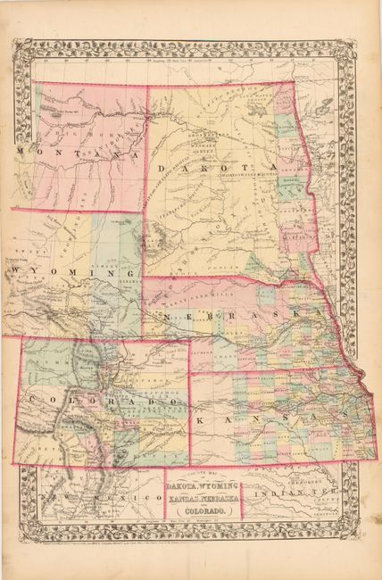
B. County Map of Dakota, Wyoming, Kansas, Nebraska and Colorado, Mitchell, 1871, hand color (14.8 x 19.8"). In 1870 Mitchell issued a new regional map of the northern plains. It replaced his previous series in a vertical format to shown the whole of Dakota Territory and the eastern part of Montana. Dakota has a band of counties in the east with the balance of the territory firmly in the hands of various bands of Sioux Indians. Montana is likewise still completely the domain of the Indians with only Forts Union and Alexander located. The proposed route of the Northern Pacific Railroad runs across both territories. Wyoming is limited to 4 counties, and is still largely unexplored north of the Pony Express Route. Colorado shows the signs of its mining boom with the Gold Region shown south of Denver. Rapid development is evident in both Kansas and Nebraska and railways are completed through both states. The western boundary of Wyoming is at the edge of the map, as issued.
References: Blevins #196, #347.
Condition: