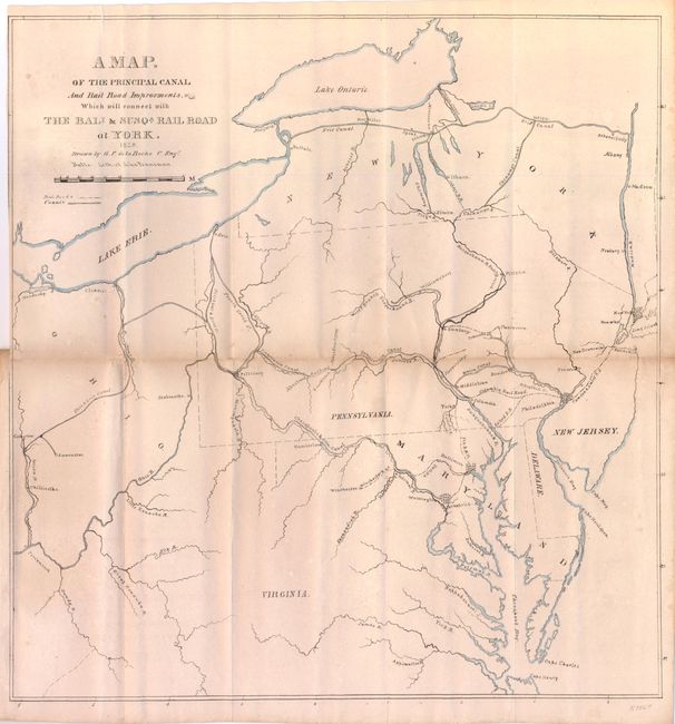
Subject: Mid-Atlantic United States
Period: 1835 (dated)
Publication: Report of the...Baltimore and Susquehannah Rail Road Company
Color: Hand Color
Size:
15.5 x 16 inches
39.4 x 40.6 cm
The map extends from Lakes Ontario and Erie to the southern border of Virginia with the major waterways outlined. Shows rivers, canals, cities and railroads at the time when canal transportation was vital to commerce and expansion of the United States. Railroads were in their infancy, and the map shows how the two (railroads and canals) would complement each other. Among the several lines shown are the B&O, Winchester RR, Oxford, Camden & Amboy rail lines, some of the earliest railroads to use steam power. According to Modelski the Baltimore and Susquehannah Railroad was chartered in 1828 and began service to York, Pennsylvania in 1838. The map names this short railroad as the B&S RR. Drawn by G.F. de la Roche, C. Engr., lithography by John Penniman, Baltimore. Folds into the original Report of the President and Directors of the Baltimore and Susquehannah Rail Road Company to the Stockholders. The report describes future planned expansion, rail miles, etc., and is signed by Alexander Nesbet, President. Printed by Sands & Neilson, Baltimore.
References: Modelski #341.
Condition: B+
The map is trimmed into the neatline for binding at left and toned along the horizontal fold with a short split at right and small fold intersection splits. There is a short tear into the top left of the map. The report is very good.