Subject: Southwest United States, Texas, Mexico & Central America
Period: 1848 (circa)
Publication: Mitchell's New Universal Atlas
Color: Hand Color
Size:
15 x 12 inches
38.1 x 30.5 cm
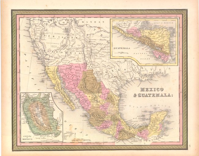
This early edition shows Texas as part of the United States, but it is not individually colored. New Mexico is shown as a small sliver of land between Texas and Sonora, extending north into the western part of present day Colorado. Santa Fe and Taos are in Texas. Upper or New California occupies much of the West, extending into today's western Colorado. The American West extends to the Pacific with Oregon Territory filling the Northwest with the Mandan region named to the east. Austin appears prominently in Texas, along with Austin's Grant, Houston, Goliad, Victoria, Laredo, Washington, and a few other early settlements. Many Indian tribes are named and located. The map presents post-Fremont geography showing the Great Basin without the earlier rivers Timpanogos, S. Buenaventura and Salado. Also notes Fremont's Peak and his routes of exploration, but Fremont's Pass is not shown. In California the Pueblo de Los Angeles is shown as are various other missions. Large insets show Guatemala and the Valley of Mexico. Blank verso. This uncommon example is lacking any imprint below the lower border suggesting an early Mitchell edition.
References:
Condition: B+
There is some minor staining and a little toning primarily in the blank margins, else very good.