Subject: Arizona
Period: 1854-55 (dated)
Publication:
Color: Black & White
Size:
38 x 23.5 inches
96.5 x 59.7 cm
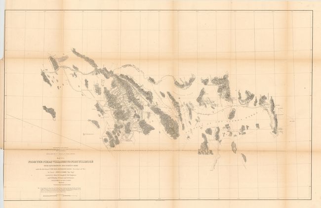
During the 1850s, the U.S. government sponsored an extensive series of expeditions designed to gather information on the vast new territories that had been acquired in western North America. The discovery of gold in California further stimulated westward traffic and heightened the need for a faster and more convenient way to bring the far-flung parts of the country together. In 1853 Congress commissioned the Army's Topographic Bureau to conduct a series of surveys to find a suitable route for a transcontinental railroad. There were six major expeditions; five of them covered the area between the Great Plains and west coast, and the sixth explored the coastal states of California and Oregon. All of these expeditions were accompanied by naturalists and artists to document the landscape, flora and fauna along the route.
The reports, maps and lithographs were published in the 13 volume report "Explorations and Surveys to ascertain the most practicable and economical route for a Railroad from the Mississippi river to the Pacific Ocean."
A well-engraved map from the southern-most railroad survey. This map represents the first survey of the area of the Gadsden Purchase, acquired by the United States in 1853 to facilitate a southern railway that skirted mountain ranges. Wheat states that the map also had "great meaning" when the Southern Pacific was built through the same area 30 years later. The map details the explorations and the proposed railroad route between El Paso and Phoenix. It delineates watersheds, plus topography through fine hachure. It is filled with information including the naming of mountains and plains, shows location of gold placers, silver mines, water holes, springs and forts. Parke had permission from the Mexican government to travel through the area, as the expedition was launched during the transition period. During the expedition he paid his respects to the Mexican governor in charge at Tucson. A very early map of the region.
References: Wheat (TMW) #851.
Condition: B+
Some minor toning along the folds and some light scattered foxing, else very good. Trim into neatline for binding at lower left side.