Catalog Archive
Auction 137, Lot 254

One of the First Geological Maps of the West

"Map Illustrating the General Geological Features of the Country West of the Mississippi River. Compiled from the Surveys of W.H. Emory and from the Pacific Railroad Surveys & other sources.", Hall, James

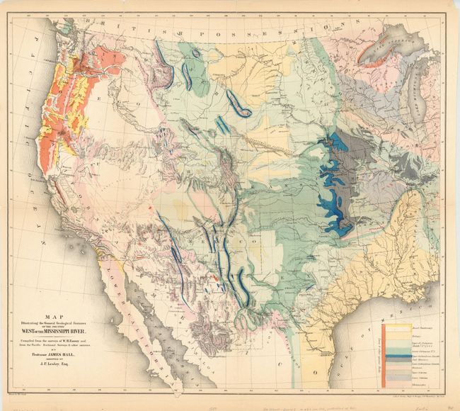
Subject: Western United States

Period: 1857 (dated)

Publication: U.S. and Mexican Boundary Survey, Vol. I

Color: Hand Color

Size:
23 x 20 inches
58.4 x 50.8 cm
Download High Resolution Image
(or just click on image to launch the Zoom viewer)

This great map of the western United States was one of the first geological maps of the region. It illustrates the many mineral resources that helped spur westward migration and expansion. The legend uses color to identify twelve geological formations. The map is also filled with terrific detail of mountains, watersheds, cities and roads. It covers the country from the Ohio River Valley to the Pacific and extends to include the states of Sonora and Chihuahua in Mexico. The political divisions include the large western territories of Washington, Oregon, Utah, New Mexico, Nebraska and Kansas. Drawn by Thomas Jekyill. Lithographed by Sarony, Major & Knapp, 449 Broadway, New York.

References: Marcou & Marcou #52; Wheat [TMW] #922; Blevins Wyoming #76.

Condition: B+

A beautiful example with bright original color. There are some fold separations with a few extending just beyond the neatline that have been closed on verso with archival tape. Hinge tape on verso.

Estimate: $600 - $800

Sold for: $450

Closed on 9/14/2011

Archived