Subject: Eastern United States
Period: 1851 (dated)
Publication: Illustrated Atlas and Modern History of the World
Color: Hand Color
Size:
13 x 9.5 inches
33 x 24.1 cm
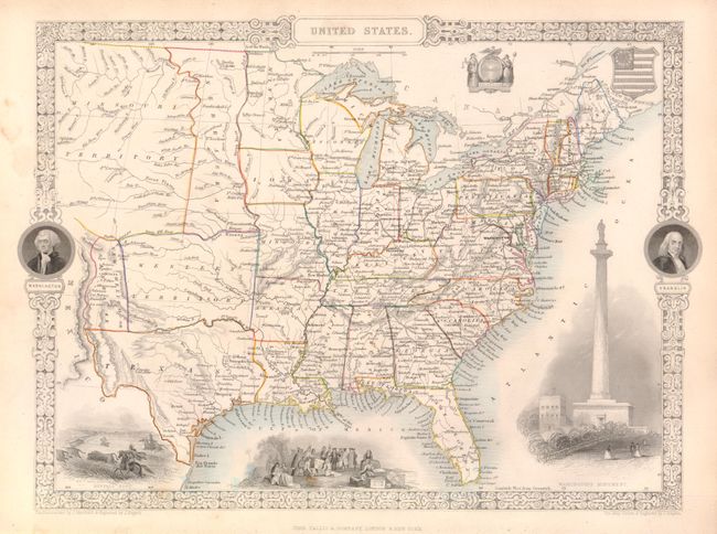
The maps from The Illustrated Atlas were first published in serial form to a target audience that led insular lives due to the expense and hardship of travel. All that changed as the progress of the nineteenth century brought swift and dramatic changes in public awareness of far away places. Tallis' maps no doubt played an important role in this dramatic awakening. These maps not only provided up-to-date geographical knowledge, but also used vignette views within the map's design to show the native people and their occupations, cities and points of interest. The maps hark back to a cartographic tradition from the Dutch mapmakers of the seventeenth century with finely engraved decorative borders. The maps were drawn and engraved by John Rapkin with views drawn and engraved by a number of prominent artists. The maps were issued as a complete volume from 1851 until about 1865. Some of the maps were also published in other history books published by Tallis including British Colonies and, without the vignettes, in geographical dictionaries and encyclopedias until about 1880.
This is a terrific edition of this map that features some interesting and unusual transitional boundaries. The large Western Territory lies above a shortened Texas and stretches between New Mexico and the western boundaries of Missouri and Arkansas. New Mexico or Santa Fe lies east of the Rio Grande, with Mexico to the west. A huge Missouri Territory occupies much of the Great Plains region, as it extends from an oddly shaped Nebraska and off the map to the west. Nebraska stretches from the Canadian border to the Western Territory as a thin strip of land lying against Minnesota and Iowa to the east. This beautifully engraved map is surrounded by a decorative border with portraits of Washington and Franklin. Vignettes of a buffalo hunt, Penn's treaty with the Indians, Washington's Monument in Baltimore, and two U.S. seals further adorn the map.
References:
Condition: A
The original outline color is typical for the period in that is was applied when children were employed as colorists. The bottom blank margins are slightly crumpled where the map was bound and there are a few small stains in the blank margin, else fine.