Subject: North America, Texas
Period: 1844 (published)
Publication:
Color: Hand Color
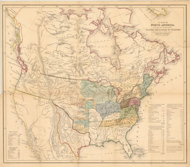
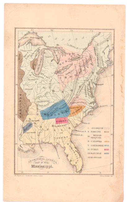
These two items were published by the Religious Society of Friends, or Quakers as they are more commonly known. These were produced for the Aborigines' Committee of the Meetings of Sufferings in London, 1844. The Quakers held these meetings every year, in which they focused on the wrongs suffered by aboriginal peoples all over the world. Both of these maps were made for a book entitled Some Account of the Conduct of the Religious Society of Friends Towards the Indian Tribes. Both maps were drawn by Jim Bowden and lithographed by H. Clark.
A. A Map of North America, Denoting the Boundaries of the Yearly Meetings of Friends and the Locations of the Various Indian Tribes, (21 x 18.5"). This map shows the United States all the way to the West Coast with a great Republic of Texas reaching into present-day Colorado. The United States has no claims to the Southwest yet, and the northwest border with Canada and the U.S. has been left undefined due to the unsettled claims in that region. The extent of immigration and developed territories is confined to east of the Mississippi. The map names all the known tribes and where they are located with a color key at left that also informs us that the Catawba, Uchee and Natchez Indians are extinct. A key shows the location of annual Friends meetings and a table at the right notes the number of tribal members of each tribe and also how many had, at that point, been moved from their homelands. B+ - Even light toning and a minor repaired tear in the left blank margin. Issued folded.
B. Aboriginal America, East of the Mississippi, (4.3 x 6.5"). The map shows the United States to the Mississippi River. It names the known tribes and locations with a color key at right that names the Algonquin, Dahcota, Huron - Iroquois, Catawba, Cherokee, Uchee, Natchez, and Mobilian Indians. B+ - Even light toning and a few small stains in the blank margin, else very good.
References:
Condition:
See description.