Subject: Montana
Period: 1887 (dated)
Publication: Senate Doc. 58, 52nd Cong., 1st Sess. 1892
Color: Printed Color
Size:
39 x 26 inches
99.1 x 66 cm
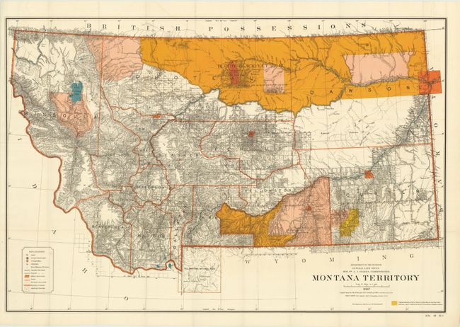
This uncommon large edition shows in great detail the extent of public surveys in Montana just prior to its statehood in 1889. Hydrology and topography are well developed on this colorful map. Remarkable detail throughout due to a scale of 1 inch to 15 miles. The map locates military posts (Forts - Assiniboine, Keogh, Maginnis, Custer, Camp Baker, etc.) Custer Hill, Custer's Monument, and the Reno battlefield; shows Yellowstone National Park in its entirety with major features. Extensive legend identifies land offices, Surveyor Generals Office, county seats, towns, villages and railroad stations, railroads (completed and proposed), military reservations, Indian reservations, railroad land grant limits, etc. The map is accompanied by the original 185-page report to Congress concerning the fragmentation of the Great Sioux Reservation in 1889. The report "Letter from the Secretary of the Interior in Relation to the affairs of the Indians at the Pine Ridge and Rosebud reservations in South Dakota" is dated March 15, 1892. This report covers the events that led up to the Wounded Knee Massacre.
References:
Condition: A+
Map and report are beautiful examples. The report is disbound.