Subject: United States - Southwestern
Period: 1878 (published)
Publication: HR Ex. Doc. No. 66, 45th Cong. 2d Sess.
Color: Black & White
This 38pp report by E.H. Ruffner, First Lieutenant Engineers was written from Fort Leavenworth on January 11, 1878.
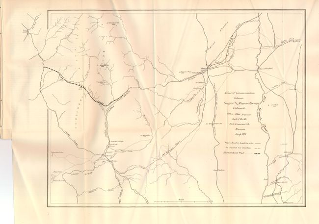
1) Lines of Communication between Conejos and Pagosa Springs Colorado (18.3 x 12.8") shows wagon roads in travelling order, those projected but not finished, and a bold line suggesting the Shortest Route West. Locates the San Antonio Route, Chama Route, the Upper Road and the route to "Tierra Amarilla via Ojo Caliente or Cuena."
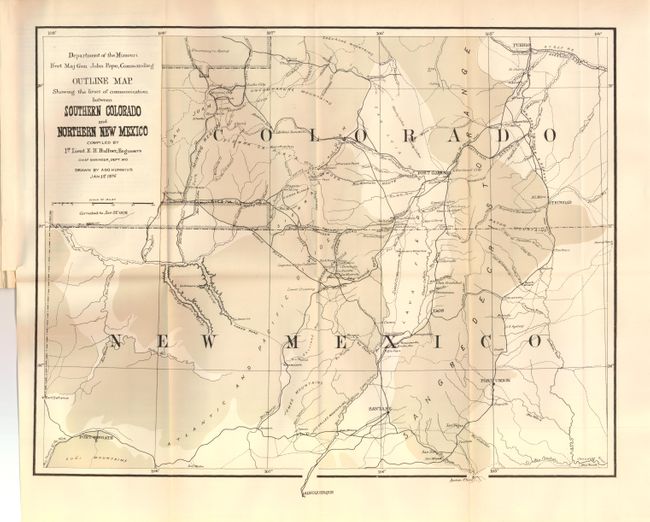
2) Outline Map Showing the lines of communication between Southern Colorado and Northern New Mexico (18.2 x 14.7"). Depicts the region from Pueblo to Albuquerque and Fort Defiance to just east of Trinidad. It provides great topographical detail as well as roads, towns, watering holes and pueblos. The map was originally issued at the conclusion of Ruffner's 1873 expedition into Ute Country, to quell the unrest between the Ute Indians and the prospectors in the newly discovered San Juan Mining Region. This is the updated 1878 version, that when compared to the first issue in 1876, was completely re-engraved without the hachure lines and carries corrections including a block of territory south of Animas and west of Pagosa.
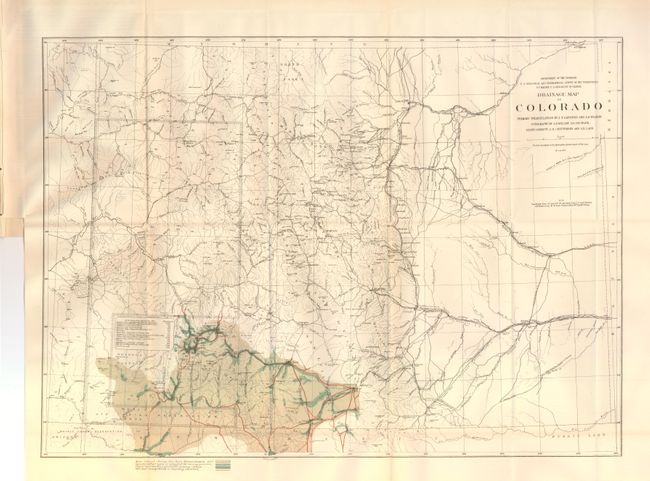
3) Drainage Map of Colorado (21.2 x 15.3"). This map presents a fine examination of the state showing abundant detail of towns, villages, mountain peaks, Indian Reservations, roads, railroad routes, forts, and other early detail. Hydrology is nicely developed with rivers and creeks shown in blue over-printing; no topographical information is given. The map details a large number of wagon roads, many named, and the route of the Atchison Topeka and Santa Fe, the Colorado Central, the Boulder Valley, and the Durango & Rio Grande (D. & R.G.) railroads, plus several unnamed tracks. The railroad is laid to the town of La Vita but has not yet reached the pass. A terrific map filled with information. Dated March, 1877.
References:
Condition: A
Slight toning on the folds and in the margins on the drainage map, else fine. Report disbound with maps attached.