Subject: Midwest
Period: 1855 (dated)
Publication: General Atlas
Color: Hand Color
Size:
15.6 x 12.8 inches
39.6 x 32.5 cm
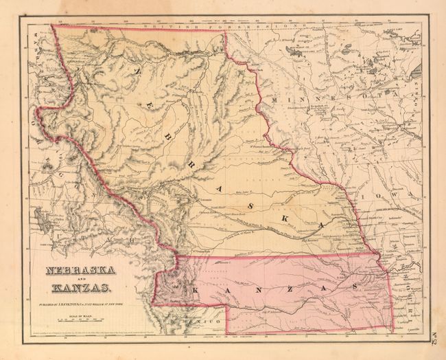
This is an important and early map of the transitional territories of Nebraska and Kanzas. In 1854, the United States passed An Act to Organize the Territories of Nebraska and Kansas with this configuration. That act also repealed the Missouri Compromise, allowing slavery in the territories north of the 36° 30´N latitude, provoking violence in this region between pro-slavery and anti-slavery settlers. Nebraska is shown as a massive territory - its northern border with Canada and incorporating the Dakotas west of the Missouri River, Wyoming and part of Colorado. Kansas also reaches west to include part of present-day Colorado. Minnesota Territory is shown at its largest extent, with its western border on the Missouri River. The territories are filled with Indian tribes; forts and a few settlements are concentrated along the major rivers. The explored routes for the proposed Pacific railroads are shown. In Wyoming the Rattlesnake Mountains make their first appearance on an atlas map. Locates Fort Laramie and Kearney, to mention a few. Names Cheyenne Pass, Devils Gate and Independence Rock. The map is surrounded with simple neatline border, distinguishing it from the strap-work border editions published in the Atlas of the Word.
References:
Condition: B+
Some toning and offsetting in image.