Subject: Colonial North America and Caribbean
Period: 1703 (dated)
Publication:
Color: Black & White
Size:
26 x 19 inches
66 x 48.3 cm
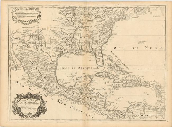
This is the third edition of this important map that is credited with accurately showing the course of the Mississippi River and its mouth for the first time. It was compiled partly from the reports of important French expeditions of La Salle, Bienville and Iberville. It is an attractive map that includes much of the present-day United States, Mexico, Central America, and the Caribbean. The map correctly shows the Great Lakes region, the English settlements along the East Coast, and the early Spanish and Indian settlements in what are now Texas and New Mexico. The early native settlement of Checagou (Chicago) is named on Lake Michigan, called Lac des Illinois after the native tribe. The name of Checagou refers to the wild garlic that grew abundantly there. The map influenced later delineations of the Mississippi River by Seutter, Homann, Lotter and others for many years. The decorative cartouche was engraved by C. Simmoneau. Dated 1703 and published circa 1708-1717 prior to Delisle's appointment to Geographe du Roi in 1718.
References: Cumming #137; Lemmon plt 16; Tooley (Amer) #50, p. 23; Wheat pp 58-61; Schwartz & Ehrenberg pl. 82.
Condition: B+
Toned on centerfold, else very good.