Subject: Western Hemisphere
Period: 1781 (dated)
Publication:
Color: Hand Color
Size:
25.3 x 17.8 inches
64.3 x 45.2 cm
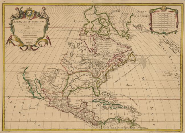
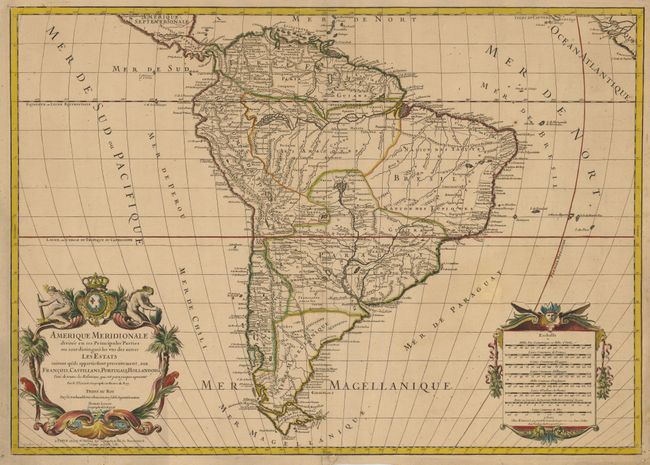
A matched pair of large America maps with an interesting publishing history. First issued by Alexis-Hubert Jaillot in L'Atlas Francois in 1695. Jaillot spent 18 years preparing the maps for this atlas, many of which he enlarged and updated from Nicolas Sanson's important maps. This popular atlas continued to be published after Jaillot's death in 1712, first by his son and then by his granddaughters. Finally the plates were acquired by Jean Claude Dezauche and Louis Charles Desnos in 1781. These American maps were published shortly thereafter with no change in cartography, but with Desnos' imprint and the date added below the cartouches. Both maps are beautifully decorated with title and scales cartouches.
The map of North America depicts the Mississippi River with a westward bend resulting in its mouth ending up in present-day Texas. The Rio Grande has been corrected so that is flows into the Gulf of Mexico rather than into the Gulf of California. The possible insularity of California is still left to interpretation with a small gap in the coastline at the head of the gulf and the northwest coastline of the continent incomplete. Politically the divisions show the colonial possessions of the French, British and Spanish.
The map of South America shows the political divisions between the French, Spanish, Portuguese and Dutch. The fourteen coastal Capitaineries created by the Portuguese are delineated in Brazil. The course of the Amazon is delineated in a fairly accurate manner, yet it shows the river's source in a fascinating, interlacing maze of waterways. The Rio Paraguay erroneously begins as a lake named Xarayes in northern Paraguay.
References: Burden #709.
Condition: B+
Light, even toning with original color. Margins have been trimmed but are still adequate with a couple holes in the margins with old paper repairs.