Subject: South Pacific Ocean
Period: 1795 (dated)
Publication:
Color: Hand Color
Size:
25 x 18.2 inches
63.5 x 46.2 cm
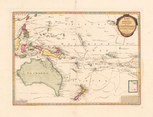
This great map of the southern Pacific Ocean covers the region from the Philippines to Hawaii, and from Australia to Easter Island. The routes of Mendanna, Byron, Roggewin, Quiros, Wallis, Tasman, Cook, Surville, Carteret and Bougainville are all charted, providing an excellent view of the voyages of Pacific exploration. It is based on a 1780 Swedish map by Daniel Djurberg, which in turn was based on the work of Lt. Henry Roberts, who served with Captain Cook on his last two voyages. Australia is labeled Ulimaroa, the name the Maoris of New Zealand used when describing 'a place to the north' to Capt. Cook. Djurberg concluded that the name referred to Australia. The eastern coastline of Australia illustrates the exploration of Cook in 1770. But the continental shape is still far from complete with a conjectural southern shoreline and Tasmania still attached to the mainland. An inset shows Cook's track south of Easter Island in 1774 along with I. St. Daniel.
References: Suarez (PAC) Fig. 173.
Condition: B+
A couple of worm tracks on the lower centerfold have been filled with a couple of place name letter in facsimile. There are some faint stains at right.