Subject: Holy Land
Period: 1598 (circa)
Publication: La Geografia…
Color: Black & White
Size:
9.5 x 7.2 inches
24.1 x 18.3 cm
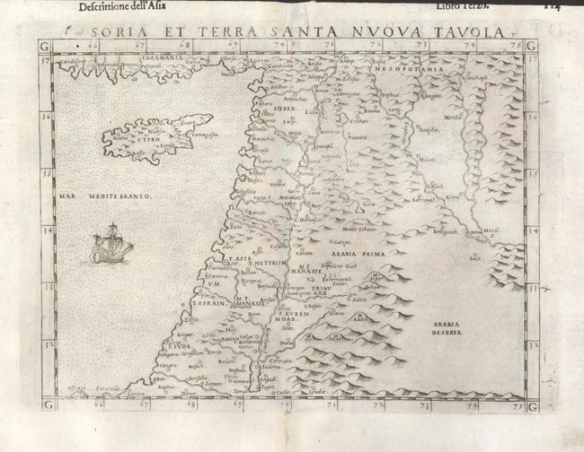
This early map of Syria, the Holy Land and Cyprus is an enlarged version of Gastaldi's important map of the same title. Girolamo Ruscelli, the editor, and Valgrisi, the publisher, improved on Gastaldi's map by following the revisions made by Gastaldi in the Holy Land area of his eight-sheet map of Asia that was published in 1561. The coastline, Jordan Valley and inland seas are much improved from earlier maps, but there are still a number of errors; Mount Lebanon (Monte Libano) is shown well east of Damascus, Jerusalem is too close to the coast, Beirut (Baruto) is too far inland, and some rivers are overstated. Still it is a remarkable presentation of the region for the time period. Engraved in the Italian style with a stippled sea with ship and mountains distinguishing the interior. Earlier editions do not have the ship in the sea which Ruscelli first added in his 1598 edition. Italian text on verso.
References: Mickwitz & Miekkavaara (Nordenskiold) #227-56; cf Laor #621; cf Nebenzahl, plt. 27.
Condition: A
On a full sheet with wide, original margins. Professional repairs along centerfold at top and bottom in blank margins.