Subject: South America - Northern
Period: 1775 (dated)
Publication: The West-India atlas
Color: Hand Color
Size:
24.8 x 18.5 inches
63 x 47 cm
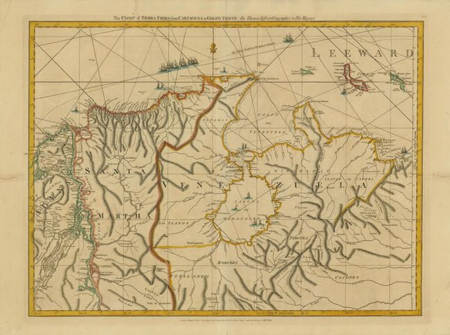
Thomas Jefferys was one of the most important English map publishers of the 18th century. His work included prints and maps of locations around the world, but his most notable maps are of North America and the West Indies. He began his career in the map trade in the early 1730s, working as an engraver for a variety of London publishers, and eventually setting up his own shop. In 1746, he was appointed Geographer to the Prince of Wales, and in 1760 he became Geographer to the King. These titles granted access to manuscripts and cartographic information held by the government. In the early 1760s he embarked on an ambitious project to produce a series of English county maps based on new surveys, but ran out of money and filed for bankruptcy in 1766. He then partnered with London publisher Robert Sayer, who reissued many of Jefferys plates and continued to issue new editions after Jefferys' death in 1771. Jefferys' American Atlas and the accompanying West-India Atlas, published post posthumously, are considered his most important cartographic works.
This superb sea chart covers part of Colombia and Venezuela from Cartagena to the Puerto Cabella and includes the Netherlands Antilles of Aruba, Curacao and Bonaire. The incredible detail extends into the interior; an area long kept under a veil of secrecy by the Spanish colonial governments. The nautical information includes soundings, navigational hazards, channels, reefs and safe anchorages. The Gallions Track from Old Spain to Cartagena is graphically portrayed with a fleet of ships. This is sheet 16 of Jeffery's 16-sheet chart of the West Indies that formed the heart of this important Revolutionary War period atlas.
References: Kapp (Colombia) #103.
Condition: A
Nice impression and original outline color. There are a couple old repaired tears in the blank margins, not affecting the map.