Subject: Texas
Period: 1865 (circa)
Publication: Illustrated Family Atlas of the World
Color: Hand Color
Size:
24.5 x 16.8 inches
62.2 x 42.7 cm
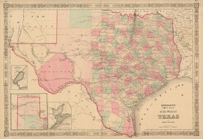
Large, handsome map with county development mostly in eastern Texas and only the three large counties of El Paso, Presidio, and Bexar in the west. The panhandle, noted as the Staked Plain (Elevated Table Land, without Wood or Water), includes a large section that is unorganized. Nice depiction of the wagon roads, many named, with several completed railroads. Insets include a Plan of Sabine Lake, Plan of the Northern part of Texas, and Plan of Galveston Bay. Decorative latticework border. Text on verso. The county development suggests the date based on the delineation of Coleman County (1864) as well as the appearance of Dawson County which was abolished in 1866. The US Mail Route is delineated on earlier editions, curiously missing here.
References:
Condition: B+
This example shows well with a good impression, delicate original full hand coloring, and full margins. Short split in margins on centerfold, the lower split enters the map. Another short marginal tear at upper left closed on verso. Three spots in blank ocean.