Subject: Illinois
Period: 1856 (dated)
Publication:
Color: Hand Color
Size:
24.7 x 39.5 inches
62.7 x 100.3 cm
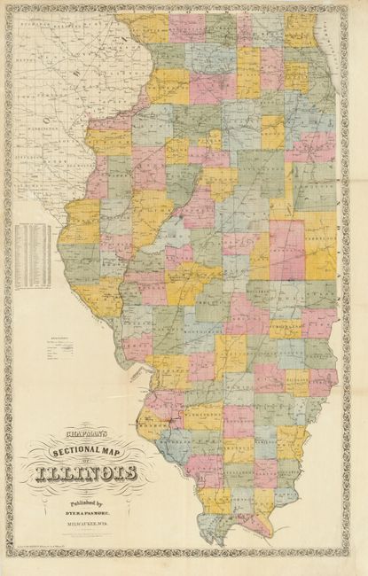
A fine large map of Illinois filled with a wealth of information including roads, railroads (completed and in progress), canals and swamp lands. A table at left lists the 1850 & 1855 census data for the counties. Lithographed by Fred Mayer of New York and published by Dyer and Pasmore of Milwaukee. Printed on two sheets of fine banknote quality paper and generally issued in pocket map format. This example appears to have been issued separately as the folds do not correspond to case map size.
Silas Chapman was an important Midwestern map publisher during the period of rapid expansion in the region (1850-1875). When he first arrived in Wisconsin he was an educator, co-editor of the Milwaukee Sentinel, and publisher of the Milwaukee Herald. He then turned his interests to book-selling, stationery, bookbinding and printing, at first in partnership with Philetus C. Hale and after 1850 alone. He was best known as a publisher of county, city, railroad, and geological maps focusing specifically on the states of Wisconsin, Minnesota, Iowa, and Illinois. Upon his retirement the Chapman firm was acquired by Dyer and Pasmore, who continued to update and republish his maps into the 1880s.
References:
Condition: A
Faint toning on a couple of folds with professional repair of a couple minor fold intersections and a couple tears in the blank margins.