Subject: California
Period: 1863-1869 (dated)
Publication:
Color: Black & White
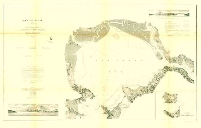
San Pablo Bay California, 1863, (38.5 x 23.2"). Very detailed large chart of the San Francisco Bay from Mission San Rafael to Benicia. Street grids of Vallejo and the Mare Island Navy yard, as well as Benicia and Martinez. Elevation views of the entrance to Carquinez Strait and San Francisco Bay from near Pinole Pt. Extensive topographic detail and sailing directions. Upper fold slightly toned with a small intersection tear (easily repaired), otherwise very good. Folding as issued. (B+)
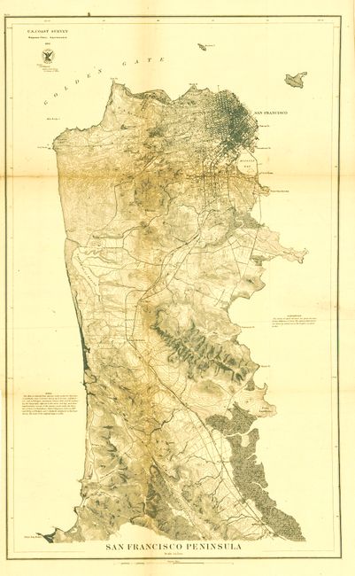
San Francisco Peninsula, 1869, (17.3 x 28"). Very detailed map that shows the peninsula from the location of today's San Francisco International Airport, here labeled Milbrae Station, and up to the city of San Francisco. The San Francisco and San Jose Railroad is shown leading into the city. The Cliff House at Pt. Lobos, the Presidio, Mission de Dolores, the large Green House Race Course, and many other interesting points of interest are noted. There is excellent detail of the city's street layout and the islands of Alcatraz and Yorba Buena detailed. Many coastal features are listed, including Point San Pedro, Fort Point, Black Point, Point San Quentin, Hunter's Point, Sierra Point and Point San Bruno. Issued folding now backed with archival tissue. Toned along some folds. (B+)
References:
Condition:
See individual descriptions.