Subject: Alaska
Period: 1778-1838 (circa)
Publication:
Color: Black & White
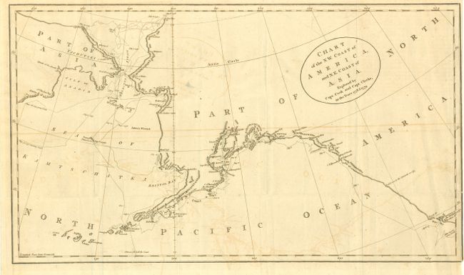
1) Chart of the N.W. Coast of America and the N.E. Coast of Asia, Explored by Capt. Cook & Clerke in the Years 1778-79, (16.8 x 9.7"). This map was published to show the west coast discoveries made during Cook's third voyage up the northern reaches of the Pacific in his search for a Northwest Passage. He probed along the Oregon coast in bad weather to Nootka Sound, where he rested and refitted his ships. They then sailed to the Alaskan and Chukotskiy peninsulas and from there into the Bering Strait. Cook got as far north as 70° 41’ north latitude before being forced back by the pack ice off of Icy Cape. The expedition continued south down the Russian coast and then east to Norton Sound. Cook's expedition continued south to Hawaii, where Cook was killed in a dispute with the natives. His second-in-command Clerke took over the expedition and explored further within Hawaii before returning north to continue explorations for the Northwest Passage. Engraver not given and no page numbers at top. Oval title cartouche at upper right. Ref: cf Kershaw #1140; cf Verner & Stubbs #40, pp. 194. Some offsetting. (B+)
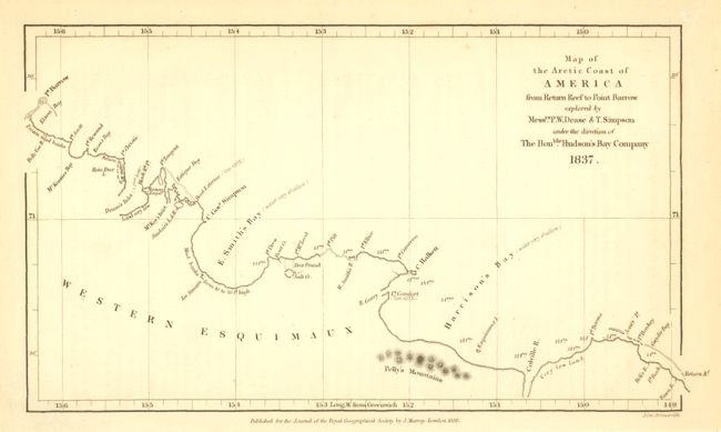
2) Map of the Arctic Coast of America from Return Reef to Point Barrow explored by Mess.rs P.W. Dease & T. Simpson under the direction of the Hon.ble Hudson's Bay Company, by Royal Geographical Society, 1838, (8 x 4.5"). Interesting little map showing these Arctic explorations on the coast of the Arctic Ocean in Canada and Alaska from the mouth of the Mackenzie River to Point Barrow. The coastline is distorted showing Alaska's western coastline as mostly straight and aligned to the north west. Light marginal toning. (B+)
3) [Untitled], (19.2 x 11.2"), circa 1825. This untitled, German-language map of Alaska shows remarkable and early detail in the interior. Locates mountains and shows excellent detail of the Kuskokwim River well into the interior. The Yukon River is shown for about 100 miles. Many rivers and tributaries are shown in varying degrees of surveying, many abruptly ending due to lack of knowledge. The map shows the coastline from Cape St. Elias in the southeast across the Kenai peninsula to include Cook Inlet and Turnagain Arm, continuing through Bristol Bay and up the western coast to the location of today's Nome. A few settlements are named along the Yukon and forts are noted on the Kuskokwim, Yukon, Nushagak and Copper Rivers. Early depiction of the Susitna River, here the Fleur Suschitna. Russian explorations in this area begin as early as the 1790s, but were uncommon until around 1818. Petr Korsakovski's expedition from Kodiak established a Fort Alexandrovski on the coast of Bristol Bay, here named as Redoute Alexander. The map extends to include Kodiak Island, part of the Alaska Peninsula and Nunivak Island. At upper left above neatline is "Baer und Helmersen Beitrage Isles Bandchen". Light offsetting. (B+)
References:
Condition:
See individual descriptions.