Subject: Southern United States
Period: 1875 (published)
Publication:
Color: Printed Color
Size:
6.3 x 9.4 inches
16 x 23.9 cm
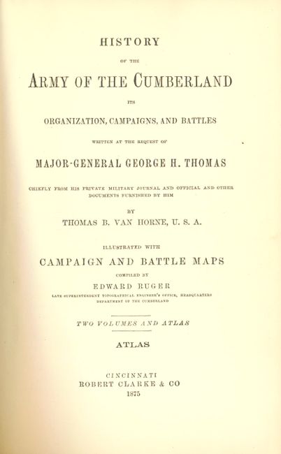
This is the complete atlas that contains twenty-two maps illustrating the various battles in and around Tennessee by the Armies of the Cumberland Ohio under the commands of Brig. Generals Sherman and Robert Anderson, and Maj. Gen. D.C. Buell. Ruger worked for the Topographical Engineers and had access to the War Department maps and plans in the production of these finely detailed and well engraved maps. Each shows highly detailed troop actions and movements with color overprinting. Published by Robert Clarke & Co., and printed by the Krebs Lithographing Co., Cincinnati. In original red cloth and quarter leather. Each map is single page and measures approximately 5" x 8" unless otherwise noted. Rarely seen in its entirety.
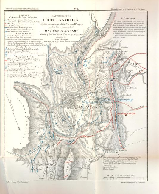
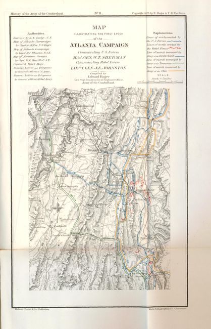
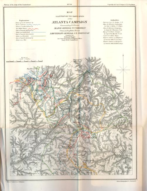
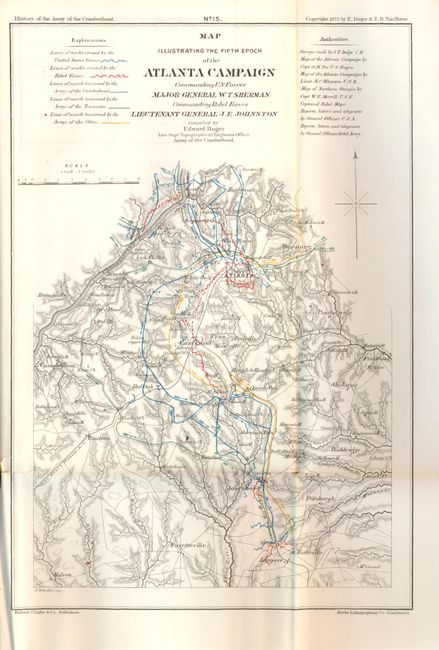
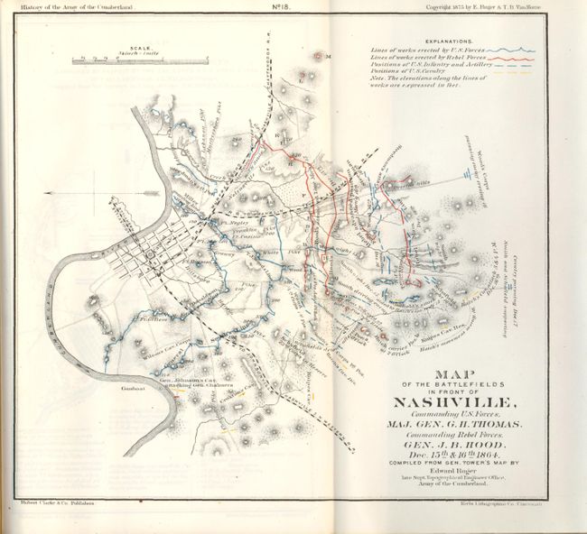
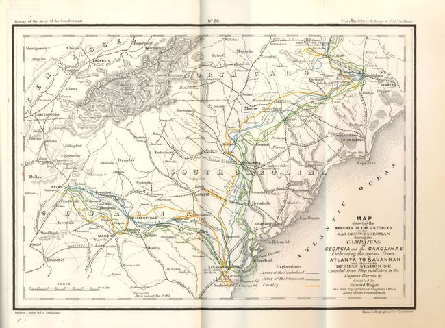
1) Map Exhibiting the Operations of the Armies of the Cumberland and Ohio…under…Brig. Gen. Robert Anderson…Brig. Gen. (now General) W.T. Sherman and Maj. Gen. D.C. Buell. (18.6 x 16.5"). 2) Map of the Battlefield of Logan's Crossroads, or Mill Springs. 3) Map of the Field of Shiloh…Maj. Genl. U.S. Grant, U.S. Vols…Maj. Genl. D.C. Buell, U.S. Vols. on the 6th and 7th of April, 1862. 4) Map of the Country between Monterey, Tenn. and Corinth, Miss. (6.5 x 8"). 5) Map of the Battlefield of Perryville, KY. (6.5 x 8"). 6) Map Exhibiting the Campaigns of the Army of the Cumberland while under the Command of Maj. Gen. W.S. Rosecrans. (17 x 14.5"). 7) Map of the Battlefield of Stone River. 8) Map of the Battle of Chickamauga…Maj. Gen. W.S. Rosecrans ... General Braxton Bragg. September 19th and 20th 1863. 9) Map Exhibiting the Chattanooga & East Tennessee Campaigns…U.S. Grant…A.E. Burnside. A fold intersection split. (18.5 x 16.5"). 10) 4) Battlefield of Chattanooga…under the command of Maj. Gen. U.S. Grant during the battles of Nov. 23, 24 & 25, 1863. (8 x 9.5"). 11) Map Illustrating the First Epoch of the Atlanta Campaign Commanding…Maj. Gen. W.T. Sherman, Commanding Rebel Forces Lieut. Gen. J.E. Johnston. (6 x 10"). 12) Map Illustrating the Atlanta Campaign… (8.5 x 11"). 13) Map Illustrating the Third Epoch of the Atlanta Campaign… (11 x 8.5") 14) Map Illustrating the Fourth Epoch of the Atlanta Campaign… Atlanta is at center. (9 x 12") 15) Map Illustrating the Fifth Epoch of the Atlanta Campaign… Atlanta well shown. (7.2 x 11") 16) Map Exhibiting the operations conducted pursuant to the orders of Maj. General George H. Thomas Subsequent to the Atlanta Campaign. (16 x 13.5). 17) Battlefield in Front of Franklin, Tenn…Maj. Gen. J.M. Schofield…Lt. Gen. Hood. November 30th 1864. 18) Map of the Battlefields in Front of Nashville…Maj. Gen. G.H. Thomas…Commanding Rebel Forces, Gen. J.B. Hood. Dec. 15th & 16th 1864. (8.8 x 8"). 19) Map of Selma, Ala, and its Defenses… 20) Map Showing the Marches of the U.S. Forces…During the Campaigns...from Atlanta to Savannah… (10 x 8") 21) Map of the Battlefield of Bentonsville, N.C. (8 x 8.5") 22) Map Prepared to Exhibit the Campaigns in which the Army of the Cumberland took part during the War of the Rebellion. (16 x 13.5"). A fold intersection split.
References:
Condition: A
Maps very clean and fine (A+) except for the general map (#1) which has two long tears and a couple splits (C+). A few other maps with short binding trim tears. Original binding is sound but has shelf wear at edges and inside covers starting from maps.