Subject: United States and Canada
Period: 1785 (dated)
Publication: Atlas Universel
Color: Hand Color
Size:
24.5 x 18.6 inches
62.2 x 47.2 cm
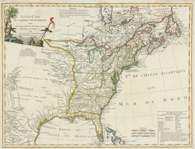
This handsome map covers the newly created United States and extends to take in much of the Louisiana Territory and part of New Mexico. Detail along the Rio del Norte includes Taos and Santa Fe. It also extends to show parts of eastern Canada and the Bahamas. It shows the original thirteen states with the southern states' western boundaries along the Mississippi River. It identifies many Indian villages and tribal territory. There are extensive notes throughout regarding early explorers such as De Soto and La Salle, Indian nations, forts and other points of early interest. One of the most intriguing features of the map is the text block, which lists the original 13 states with their capitals and also ten new states proposed in the Jeffersonian Ordinance of 1784 - Silvania, Michigania, Chersonesus, Arsenistpia, Metropotamia, Illinoia, Saratoga, Washington, Polypotamia, and Pelisypia. This is the first reference on any map to Michigan as applying to a land division of the United States. The title cartouche has a nautical theme. The map was published by Antoine Boudet in a later edition of the Robert de Vaugondy atlas. This map was also published by Delamarche after Boudet's death in 1787 and it is often attributed to him.
References: Karpinski (MI) #CIII; McCorkle #785.5; Pedley p. 227; Seller & Van Ee 761.
Condition: B
There has been some moisture damage in the map corners and centerfold resulting in some tears and paper weakness. All have been repaired and are now unobtrusive.