Subject: Continents
Period: 1852-54 (circa)
Publication: The Physical Atlas of Natural Phenomena
Color: Printed Color
Nice lot of thematic maps from the English version of Heinrich Berghaus' Physikalischer Atlas, the first truly comprehensive thematic atlas. These are very early examples of printed color, the development of which made a huge impact on cartography in general and specifically on the graphic portrayal of geographical data on thematic maps. Each is surrounded in a keyboard style border.
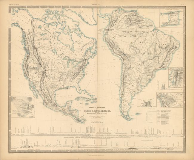
1) The Physical Features of North & South America showing the Mountains, Table-Lands, Plains, & Slopes, 1852, (24.2 x 20"). A very finely engraved chart that is filled with information. The map of North America has good detail of the Rocky Mountains, the Great Basin, the topography and watershed. The cross-sections that fill the lower portion emphasize the geological nature of the North American continent. More detail is shown with insets: Island of Trinidad; Table-Land of Quito; Enlarged Map of the Andes of Bolivia; Volcano of Jorullo; Section of the Table-land of Bolivia; and Section of the Table-land of Quito. Another section indicates the complex geology of the Appalachian region. Wide margins with centerfold splits into border at top and into map at bottom.
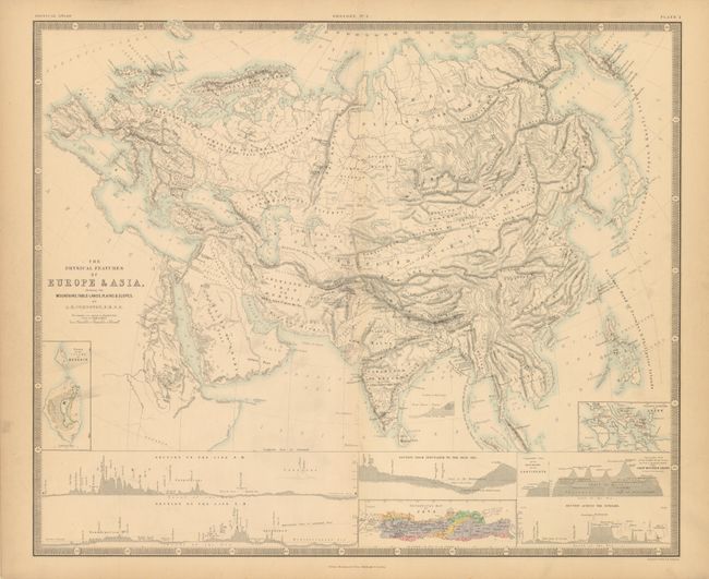
2) The Physical Features of Europe & Asia, showing the Mountains, Table-Lands, Plains & Slopes., circa 1852, (24.2 x 20"). Another finely engraved double-page map with great detail showing the terrain, rivers and naming the major towns. Several insets fill the lower section including the Volcanic Kingdom of Luzon, the Raising of the Island of Reguain, a Geological Map of Java and four sections including the Comparative View of the Mean Height of the Continents. Two light and diffuse smudges at left edge with a short fold separation at top.
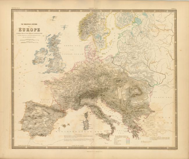
3) The Mountain Systems of Europe Constructed on the Basis of Contour Lines from the Drawings of Professor Berghaus, Berlin., 1854, (22.8 x 19.2"). This exceptional thematic map features bold, dense engraving to identify the terrain of Europe. A legend uses color to further identify the mountains into the Hesperian, Alpine, Sardo-Corsican, Sarmatian, British and Scandinavian Systems. The remarkable amount of ink, which can be felt on the paper, has resulted in some offsetting, a small price to pay for the beautiful result. On thick paper with short splits on centerfold. (B+)
References:
Condition: B
See descriptions.