Subject: Australia
Period: 1834 (dated)
Publication: Atlas Universel de Geographie Physique, Politique et Historique…
Color: Hand Color
Size:
21 x 14.3 inches
53.3 x 36.3 cm
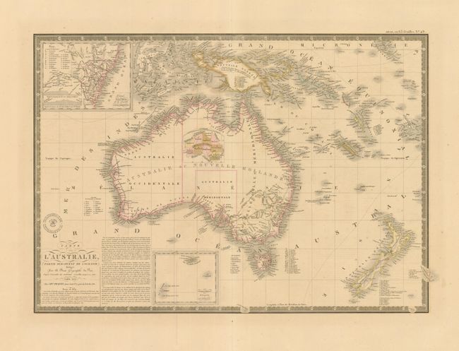
This is a terrific and attractive map of "New Holland" which includes New Zealand and New Guinea, plus many smaller islands of the East Indies. The coastal detail is exceptional with a large number of place names. The interior is virtually blank, but an inset map in the middle of Australia delineates the original nine divisions proposed by Captain Vetch of the Royal Corps, namely Dampierie, Tasmanie, Carpentarie, Torresie, Victoria, Nuytsland, Flindersland, Cooksland, and Guelphie. An inset of the southeast coast (Details de la Colonie de la nouvelle Galles Meridionale) is centered on the unnamed Sydney and has a key locating the nineteen political divisions. The inset locates Port Macquarie, Port Jackson, Port Hunter, Port Stephens, Botany Bay, and extends into the interior well west of the Blue Mountains. This is the updated 1834 map from the 1826 edition. With Brue's embossed seal and a decorative keyboard-style border.
References:
Condition: A
Great impression and fine original hand coloring on thick sheet with very wide margins. A few tiny spots do not detract.