Subject: Polar
Period: 1780 (circa)
Publication: Histoire Naturelle Generale et Particuliere
Color: Black & White
Size:
36.5 x 19 inches
92.7 x 48.3 cm
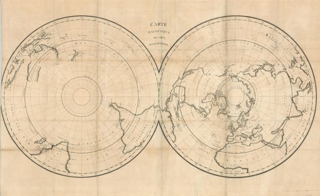
This scarce and unusual twin hemisphere map is presented on a polar projection. The approximate position of the northern magnetic pole, indicated by a large shaded area, is located just north of the Arctic Circle. The variations in terrestrial magnetism at different points on the earth's surface are indicated throughout the map. The boldly engraved map shows only the continental outlines with few country and place names. Alaska is in a rudimentary shape, the southern coast of Australia is still unknown and Tasmania is thought to be connected to the mainland. The chart reflects the latest discoveries with evidence of Capt. Cook's Pacific surveys, La Perouse's last voyage to the Pacific in 1775, and also the work of Jean-Charles Borda who is credited with the first observations on the variations in terrestrial magnetism. The map is sometimes attributed to La Perouse, but was published in the scarce mineralogy section of Buffon's Historie Naturelle.
References:
Condition: C+
Issued folded, now flattened with tissue reinforcement of folds. Trimmed into neatline at left, apparently as issued. There is some toning along the folds and there are a few short folds are still separated.