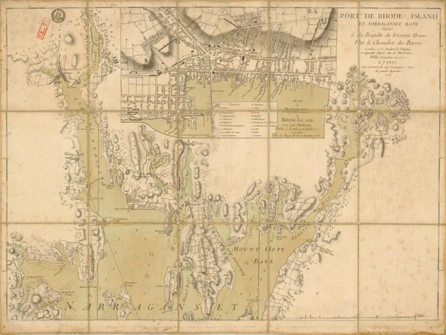
Subject: Rhode Island
Period: 1778 (dated)
Publication: Pilote americain septenentrionale
Color: Hand Color
Size:
27.6 x 20 inches
70.1 x 50.8 cm
This important and scarce, Revolutionary War period chart is based on the third of Des Barres' chart of Narragansett Bay, which in turn was based on a Charles Blaskowitz manuscript "A map of the bay of Naraganset with the islands, therein and part of the country adjacent." This is the northern sheet of the two-sheet map. The map is sectioned and laid on linen and self folds with paper labels on the verso. The map details the area locating Providence, Warwick, Potowoom, Bristol, Warren, Barrington, Swansea and the extensive and tortuous waterways in the region. It locates roads, individual structures, mills, college, hills, and even stone wall field boundaries. Soundings in the bay are noted in fathoms. The large inset map of Newport is even more detailed and displays the street layout with individual structures on each block shown. Titled "Plan de Newport en Rhode Island…" it was taken from another Blaskowitz manuscript map: "A plan of the town of Newport in Rhode Island..." At the bottom the index locates and names 18 public buildings including the Touro Synagogue, which is the oldest standing synagogue in the US. The plan locates two windmills in Newport include the now famous Newport Tower. Blaskowitz conducted his surveys under the direction of Samuel Holland, Surveyor General for the Northern District of North America. While neither Des Barres or Le Rouge attributed their geography to Blaskowitz, the following year William Faden published the surveys in his name.
The map folds down to 6" x 7" with old paper labels at both sides, apparently for identification and cataloguing. Under one are the initials "I.E. C. Ro" which a prior French owner claimed is a connection to General Rochambeau and his staff, but we have not been able to verify this claim. On the verso the map is numbered in manuscript No. 28.
References: Sellers & Van Ee #1000
Condition: B+
There are some minor holes at the fold intersections and some soiling and foxing else is good or better. There are two very old stamps in the upper left, one is from the French War Department.