Subject: Southwestern United States
Period: 1853 (published)
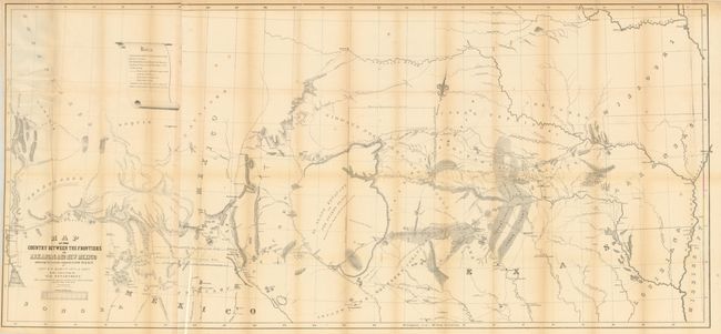
Publication: Exploration of the Red River of Louisiana in the Year 1852
Color: Black & White
Size:
60 x 27.5 inches
152.4 x 69.9 cm
The title continues "5th U.S. Infy. under orders from the War Department. Also a continuation of the emigrant road from Fort Smith and Fulton down the Valley of Gila." This is a most informative map of the region illustrating the explorations of Capt. Marcy, with inputs from Col. Emery's Boundary Survey, Capt. Sitgreaves' map, as well as those of A.B. Gray and J. de Cordavas. It details the area from the Mississippi River to the Colorado, and from about 30° N. latitude to the Arkansas River. North of the Gila River the region is noted as Unexplored, with a legend reading, "In the vicinity of this place a tract of country is found which is said by several trappers to be exceedingly fertile, and abundantly timbered and well watered." This erroneous note (in the Sonora Desert) shows up a decade later on A.J. Johnson's early maps of the Southwest. Filled with a copious amount of important information and detail on Oklahoma, North Texas, New Mexico and Arizona, the map locates exploration routes, Indian tribes, disputed territories, and much, much more. Wheat says this map is "one of the best of the period."
References: Wheat (TMW) #791.
Condition: B+
Very nice example with just a little light fold toning and occasional archival tape to support fold intersections on verso.