Subject: Colonial Mid-Atlantic
Period: 1769 (published)
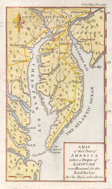
Publication: Gentleman's Magazine
Color: Hand Color
Size:
3.8 x 6.5 inches
9.7 x 16.5 cm
This interesting little map covers the Delaware peninsula north to Philadelphia with only a few cities and roads including Annapolis, Baltimore, and Greenwich. It locates many early settlements and shows the roads that connect them. The focus of the map is the initial measurements made by Charles Mason & Jeremiah Dixon for what has become known as the Mason-Dixon Line. These two British astronomers were employed to make this survey in order to resolve a long-standing dispute between the Calvert family, proprietors of Maryland, and the Penn family of Pennsylvania. This map, one of the first to show the results of the Mason Dixon survey, shows this initial degree of latitude set into the context of the lands around the Chesapeake and Delaware Bays. The map is a slight variant of a map that appeared the previous year in The Philosophical Transactions of the Royal Society of London, reflecting the general public interest in this border dispute in the American colonies.
References: Jolly GENT-199.
Condition: A+
On very thick paper with strong impression. Close right margin.