Subject: Eastern United States
Period: 1806 (dated)
Publication: Atlas Universel de Geographie Physique et Politique
Color: Hand Color
Size:
18.7 x 14.8 inches
47.5 x 37.6 cm
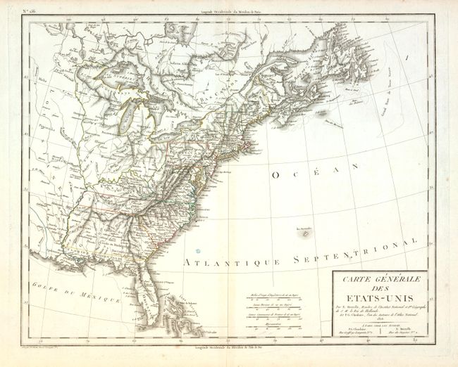
East and West Florida underwent several boundary and sovereignty changes during its history. The two regions were established in 1763 by the British colonial government out of land taken from France and Spain after the French and Indian War. Reasoning the newly acquired territory too large to govern, the British divided it into two new colonies separated by the Apalachicola River.
West Florida was based in Pensacola, and the colony included the part of formerly Spanish Florida west of the Apalachicola, plus the parts of French Louisiana taken by the British. Its northern boundary shifted several times over the years. East Florida has as its capital St. Augustine, which had been the capital of Spanish Florida.
Both remained loyal to the British crown during the Revolutionary War, and served as havens for Tories fleeing the Thirteen Colonies. In 1781 Spain invaded West Florida and captured Pensacola, leading Britain to cede both to Spain following the war. The ill defined boundaries led to a series of border disputes between Spain and the nascent United States known as the West Florida Controversy. Disagreements with the Spanish government led settlers along the gulf coast to declare the area the independent Republic of West Florida in 1810. The area was soon annexed by the United States, claiming the region as part of the Louisiana Purchase. The remainder of West Florida and all of East Florida were purchased by the United States in 1819 under the terms of the Adams–Onís Treaty. Florida Territory was formed as a result.
This finely engraved map shows the United States extending to the Mississippi River. It extends westward beyond the Mississippi River to show a portion of Louisiana Territory with numerous Indian tribes located on the frontier. The western boundary for Georgia is at the Mississippi River and the oversized Florida is composed of East and West Florida. There is significant detail with a surprising number of towns and settlements located. Published by Chanlaire & Mentelle.
References:
Condition: B+
Hint of centerfold toning and a small blue ink or paper stain in blank Atlantic. Full margins, two watermarks, fine impression and original color.